A Wander Through Places and Items of Interest
Extracted from Hugh Marwick’s The Place-Names of Rousay
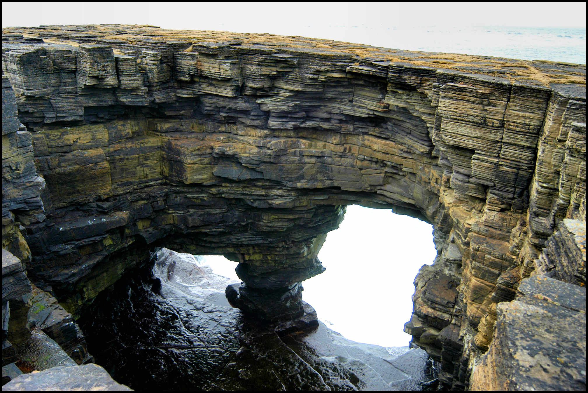
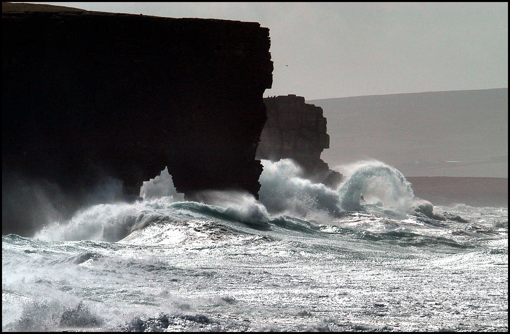
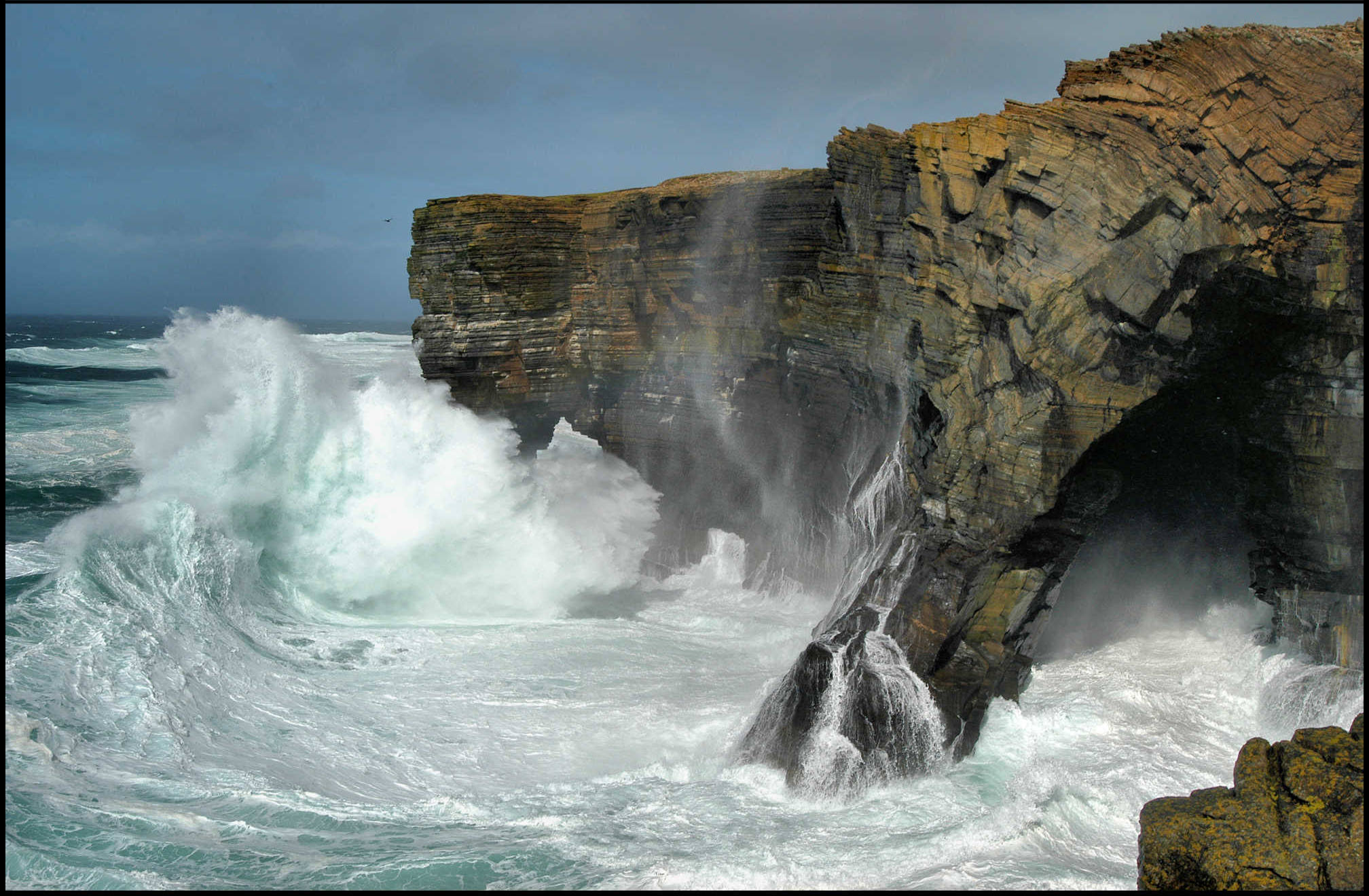
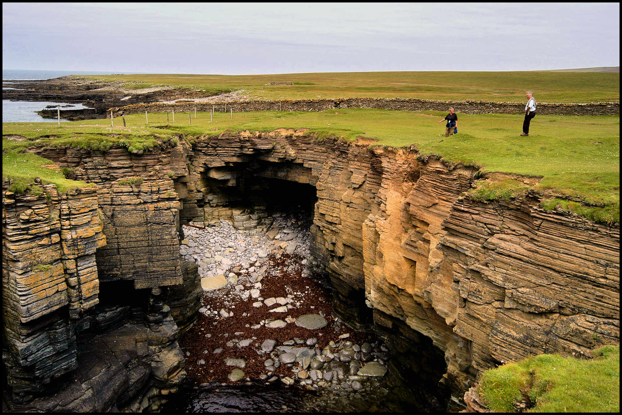
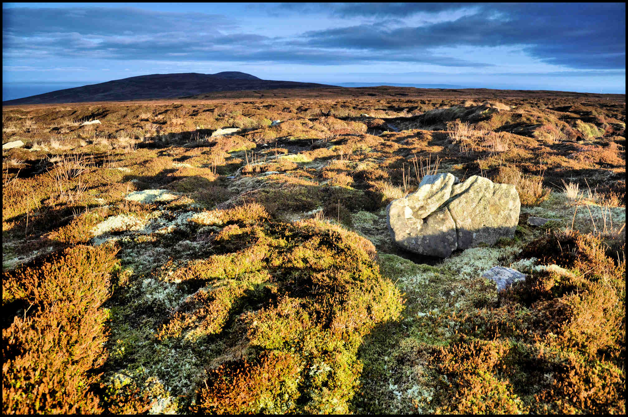
KILNS OF BRIN-NOVEN, slightly to the west of Sacquoy Head and pictured above, are great yawning chimney-like pits or chasms situated near the edge of the high cliffs which form the coastline here. Cavernous openings have been formed at the foot of the cliffs by the ceaseless wash of the waves. Through some weakness in the rock-formation over the inner ends of these caves, and aided by the tremendous pressure and suction of the waves, whole masses of rock have collapsed, leaving these awesome-looking chasms, at the bottom of which the waves can be seen dashing about and throwing up spray almost continually. On stormy days, spray and spume are blown up to a considerable height above the ground like smoke from a kiln – hence the use of that term. The photo below shows the Kiln of Dusty, to the west of here and closer to Bring Head.

KNAPKNOWES is the name of a vanished farm at Quandale, its occupants and the rest of the population in that area being driven off their land in the first clearance of 1845. In 1936 three mounds were excavated at Knapknowes by Walter Grant, his investigations revealing the fact they contained burials. The first covered a cist [small stone-built coffin-like box] containing cremated bone, ‘cramp’ [vitrified fuel ash slag, known as cramp in the context of Bronze Age Orcadian funerary practices] and six small pieces of flint. The second, crossed by a drystone dyke, covered two cists, one of them central, both containing cremated bone and cramp. The third mound covered an upright Cinerary Urn [an urn for holding a human’s ashes after cremation] in a stone setting and containing cremated bones and ‘cramp’. These three cairns were located close to the farmstead of Knapknowes, evidence of which was scarce for the footings and walls had been used to build the nearby dykes. One other mound on the site was also excavated by Grant, but it was in fact the remains of the corn-drying kiln associated with the farmstead.
KOLDEROSS is a narrow shelf on the face of a crag immediately west of Hunber, near the Knee of Faraclett. This is another of the well-known but dangerous fishing sites in Rousay – the shelf being so narrow that for safety anglers had to sit down to fish, their legs dangling over the edge: hence the name – in Old Norse kaldi-rass, ‘cold arse’!
John Gibson of Broland fell into the sea from this ledge. The men around him cast their ‘waands’ at him, and caught him on the collar with their ‘flees’ and saved him.
KOOGROO is a small green hollow covered with rough pasture, south-east of Loomachun and south-west of the Loch of Jan Janet. Part of this is known as the Courtha’ of Koogroo where kye used to be herded.
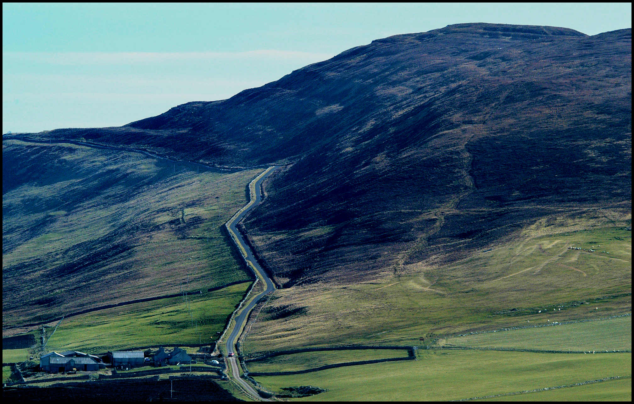
LEEAN is a mile-long stretch of the very steep northern slope of Kierfea Hill between Sourin and Wasbister, which ends in dramatic cliffs and caves and the sea at Saviskaill Bay, between Faraclett Head and Saviskaill Head. The photo above shows the road snaking up past Langskaill and disappearing as it passes Blossom Quarry top left.
Bya-steen is the name of the best fishing rocks in the Leean. Others, already mentioned above, include Garaber, Klettber, Kribbany, Salt Hellyie, Sandber, Steenathy, and Verpino. ‘Furto’ in the Orkney dialect is bait thrown out on the water to lure fish, especially in rock-fishing for cuithes or sillocks. The true old furto consisted of chewed limpets which had been previously ‘leeped,’ or scalded, to take off the shells. Fishermen then chewed these limpets into small portions and ‘spat out furto’, which caused an oily smooth patch on the water known in Rousay as a ‘linyo’.

Handi-Midgarthy is a name applied to a point about half-way up the Leean road where the hillside slopes down in a particularly abrupt and precipitous manner.
Garsnigeo is a deep precipitous geo at the point where the line of high cliffs running west from the Knee of Faraclett turns at right angles towards Wasbister; Campie Rowo is a prominent ridge of reddish cliff jutting out on the line of high cliffs north-west of Garsnigeo; the Riff of Lythe is part of the shore in the Leean, north of Campie Rowo. The Riff is an extensive reef of flat shelving rocks stretching out seawards from the base of the high cliffs, and usually covered at high water; and Ollyer Tong and Scaraber are points of rock on the Leean shore.
The photo above shows the Leean skirting Saviskaill Bay, the calm waters of the Loch of Wasbister in the foreground. Tommy Gibson of Brinola tells a story about a large ship partly laden with dried tea-leaves which went ashore in the Leean. The people of Wasbister and Quandale did not know what to do with the cargo. They tried to feed it to the cattle, with no success. They even tried to make porridge out of the tea and they also tried to smoke it. In the end they used the tea for bedding for the cattle and pigs!
LOBUST. The Lobust is a massive pillar of rock or stack between Helliaspur and the Kilns of Brin-novan, with a natural arch bored through its base. It is separated from the coastal cliffs by a chasm just half a dozen yards or thereby, and rising precipitously from the sea to a height roughly level with the top of the adjacent cliffs. It is one of Rousay’s ‘sights’ and specially interesting by reason of its very inaccessibility. Above is a view from Sacquoy Head on Rousay, with Costa Head and the Brough of Birsay appearing on the far horizon. The dot of light in the dark cliffs to the left is the natural arch at the base of the Lobust.
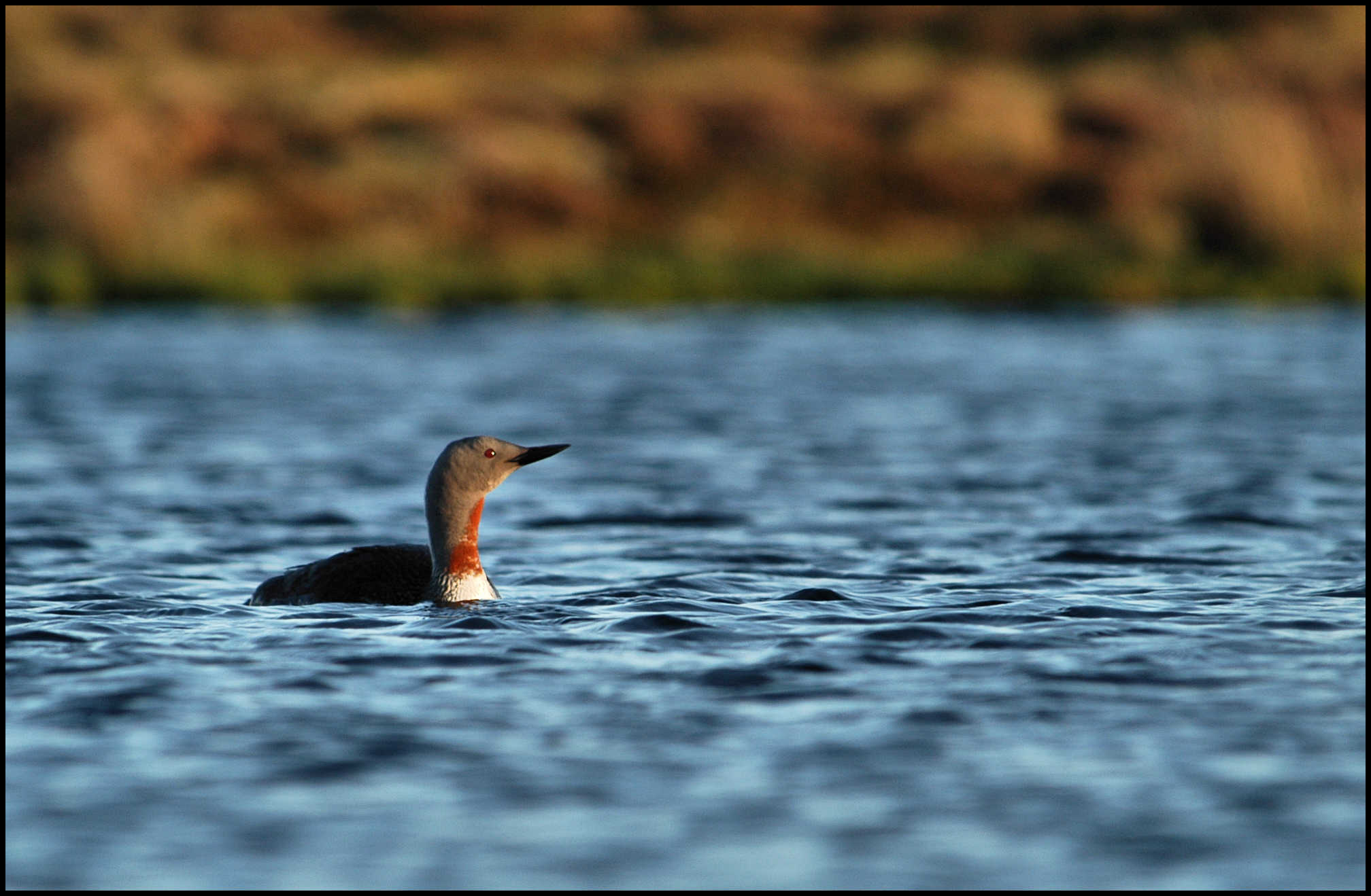
LOOMACHUN is a loch or tarn on the top of the Brown Hill, about half a mile north-east of Muckle Water. The Old Norse lóma-tjqrn translates to the ‘tarn of the loom,’ or red-throated diver. In Orkney this bird is known as the rain-goose. Hugh Marwick once asked an old Rousay man if he had ever seen a rain-goose. “Yea’m I, boy, an’ I’m seen the eggs o’ her, too.” “Where,” Marwick asked. “On the Loch o’ Loomachun,” was the reply. The same year a friend of Hugh Marwick’s told him that his son had found a rain-goose’s nest at the same place a few weeks before.
Year after year, down the ceaseless procession of the ages, amid the tumult and change of human affairs, instinct has brought this bird back to nest on a tiny islet in the Loch of Loomachun, just as it did when the name was first bestowed, and doubtless for centuries long before that.
A short distance to the east of Loomachun is the Loch of Chin-chinnet. On an old map it is spelt Jin-Janet, but Orcadians normally pronounce the letter ‘j’ as ‘ch’. This is a tiny tarn, supposedly very deep, but the origin of the name is unknown.
MYRES. Over 100 years ago an old man in Rousay recorded an account of something that had happened in the Brings area of Wasbister when he was young in the early 1800’s:
‘About the commencement of the century, a child by the name of Mowat, about two years old, strayed from the house of Myres in Sourin in a thick mist. His parents sought him for two days in vain. A dog belonging to Furse in Wasbister was missed the same day as the child went away. The dog came home on the third day and got some food. He went away as soon as he had taken it. He was followed by the servant man. The dog ran to a pigsty in the Brings, and when the man went to the sty the dog made for springing at him. He looked in and found the child alive and well. He took the child home and went and told the parents who gladly came for him. He lived in Rousay to an old age, I knew him well. The most remarkable thing about it was that before the dog would venture home for food he had sent all the swine about a mile from the sty in which the child was found.’

NUGGLE is the name of a pointed or rounded projection on the northern hill-ridge above Wasbister, between Moan and Innister. On the Ordnance Survey map of today it is called the Too of Nugle. In land charters of 1628 and 1655, the name Knowgill is on record, denoting a patch of udal land somewhere in Wasbister, and, according to Hugh Marwick, must be the same name. The Old Norse word knykill means a hump or protuberance.
OLDMAN was the name of a small hill croft in Sourin on the south bank of a burn of the same name. It is an example of another transferred name, for the original Oldman was on the Westside, between the present third and fourth fields out from Westness farm. Tenants were cleared from the Westside and their lands laid down as a sheep-walk. Some of the evicted settled on new sites in Sourin – as here at Oldman – and the old house name was applied to the new.
POPULATION. The population of Rousay in 1841 was 971. There were 287 folk living in Wasbister; 307 in Sourin; 42 in the Brinian; 121 in Frotoft; and 214 in Westness and Quandale.
PRAYER SITES. Praying crosses, by the wayside, were a familiar feature in the old days, and particularly at places where the traveller came into view, or lost sight of, a church or holy place. In Rousay there are two, if not more, of these sites commemorated in place-names.
Corse, in Frotoft, was one of these. It was a house built near an old Corsegate or road to the church. In this case the church was probably the old parish church of Our Lady at Skaill, but it is not improbable that the place to which pious eyes here turned was the more venerable church on the Holy Isle of Eynhallow.
On the western slope of Mansmass Hill, the northern spur of Ward Hill, a park just above the public road was known as Bonie Hole, the Old Norse bonnar-hill means prayer-hill. ‘Bonie’ was a word that occurred in the common Rousay phrase for prayers – especially a child’s prayers at bedtime – bonie-words. Here again we have another example of the same custom as we saw at Corse, and the church in this instance was also apparently the parish church at Skaill.
Further on into Wasbister the old road to that church is remembered in the house name of Kirkgate.
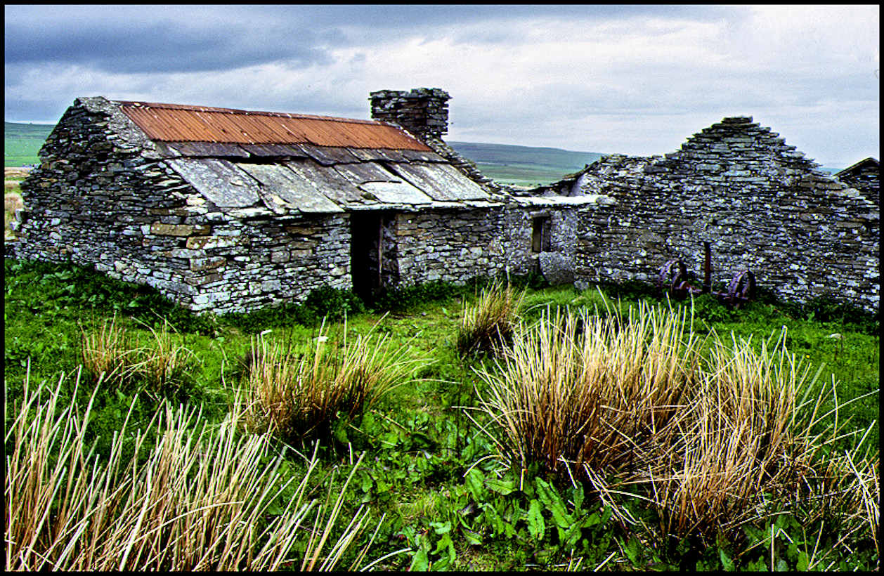
PRETTY was the name of a croft in Sourin [pictured above], having been shortened from its official name of Standpretty. In giving evidence before the Crofters Commission in 1888, the tenant James Cooper, Standpretty, deponed that his father and grandfather had been in the croft before him, that they “had settled on the bare hill, built all the buildings, and reclaimed all the land.”
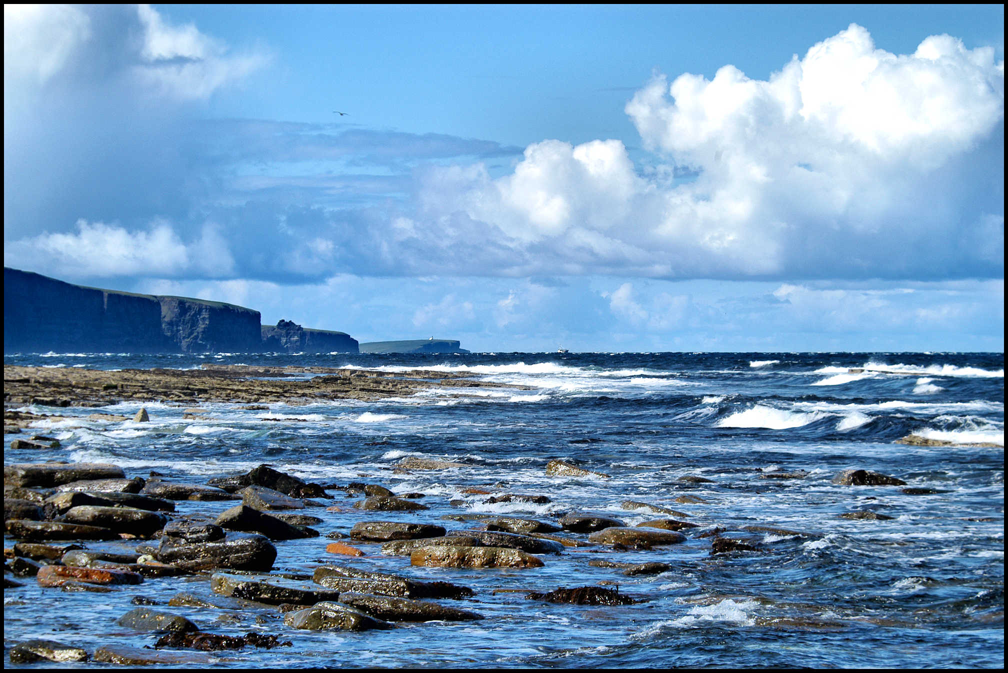
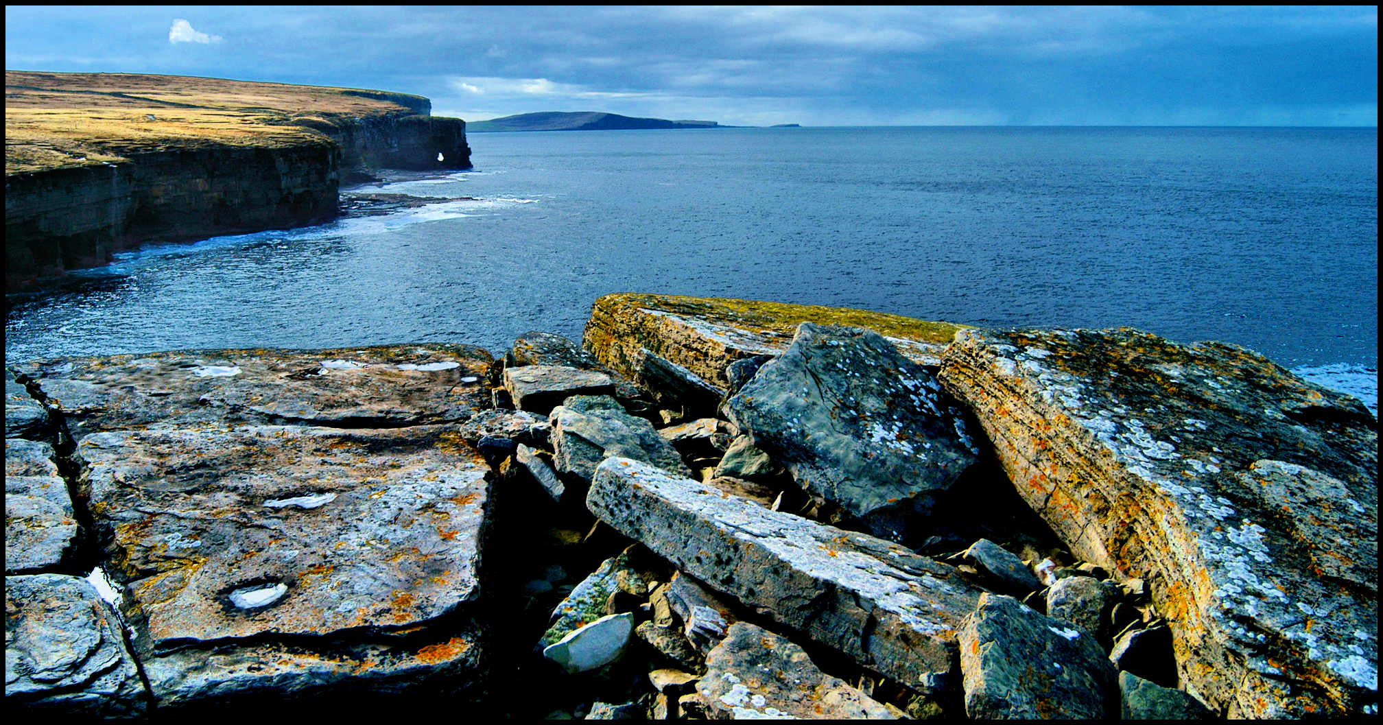
QUOYNALONGANESS is the western-most tip of Rousay, and in some instances was known as the Point of Treaudale. In Old Norse kvi-in-langa – ‘the long quoy’, and such a quoy [enclosure for animals] was once situated nearby. Part of the beach here is known as The Quoy of Quoynalonganess. The photo above was taken from here, and looks across the entrance of Eynhallow Sound, with Costa Head and the sea-stack known as The Standard. The lighthouse on the Brough of Birsay is just visible in the middle distance.
REEKY KNOWE is the name of a mound on the beach below the Westness farmhouses, on which fires were supposed to have been lit for communication with Eynhallow.
SCABRA HEAD, with its impressive Hole o’ the Horse natural arch, is the bold rocky head-land forming the dominant feature of the coastline on the west side of the island. The name derives from the Old Norse word skjald-breiðr, denoting some natural formation ‘broad, like a shield.’ Other geological features here include the Ha’ and Knee of Scabra.
There used to be a farm nearby called Skaebrae, reckoned sometime as a 5d. land. Between 1733 and 1740 it was occupied by Ursula Marwick. It then passed into the hands of John Couper who was married to Jean Ballenden and they had a son Magnus. In 1799 George Hercus and his wife Christian lived and worked there. The farm and its land later became part of Westness Farm.
SINCLAIR’S HILL is up above Hullion. A nearby valley is called the Hass of Glifter, and in the same vicinity are the Loch of Pitcho, Vassay and Upper Vassay. Turloul is east of Glifter, south-east of which is Lou-o’-fiold – and Kesburn is a hollow in the landscape south-west of there.

SINIANS o’ CUTCLAWS – a massive collapsed cave with cavernous openings on the seaward side of the adjacent cliff between Quoynalonganess and Scabra Head. Cutclaws was the name of a now vanished house that stood nearby, occupied in 1738 by William Bichan, and in 1841 by Alexander Logie who paid rent of £3.0.0. In 1843 it was absorbed into Knapknowes and later added to Westness farm.
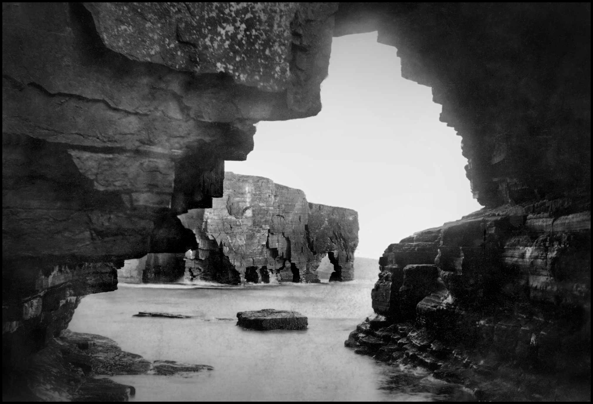
Below is a Tom Kent photo [courtsey of Orkney Library & Archive] taken in the early 1900s from inside the Sinians, looking out towards Scabra Head and the Hole o’ the Horse.
SLAP OF AKLAR is a name found on an old estate map of Westside. It was the name given to a gateway, or slap, in the old hill-dyke above Whome. The Old Norse word axlar means a ‘shoulder.’ It is also used metaphorically for a shoulder of a hill or a knob on a hillside. In this case a shoulder of Mansemass Hill juts out here.
SUSO BURN, a small stream which flows out of the east end of Muckle Water and flowing in a north-easterly direction to Hanover in Sourin where it is joined by the Burn of Goustie. It then changes its name to Mill Burn from this point finally flowing into the sea.
STEENI-VESTIFAL was a name applied to part of the lower north-east slope of Blotchniefiold, just above the main Sourin peat-banks. In his Tour Through the Northern Isles of Orkney, which he made in 1778, the Reverend George Low refers to a ‘standing-stone’ in Rousay at Westoval. According to Hugh Marwick that name, now unknown, can be no other than the second element in this name, and the standing-stone, of which no sign is now visible, explains the first element, the whole compound thus meaning – ‘the standing-stone at west hill.’
STURDIE STEP is a name given to a point on the west side and near the north-west corner of Muckle Water, and consists of a few large rocks on raised ground. Strandy-Gate was the name of the road on the east side of the Loch of Wasbister running down to the beach, or strand.
STYES OF STEENIE-IRON, pronounced stin-i-ai-ern, is an old ruinous site about a quarter of a mile east of Peerie Water. Hugh Marwick thought it one of the most interesting of Rousay names, the apparent combination of stone and iron making. He thought it was not impossible that there may once have been styes here where the swine of Westness, which were sent to roam the hills in summer, might have found shelter. It is at least equally possible that some very ancient primitive buildings existed there, of such a rude nature that they were regarded by later generations as having been styes at one time.
Marwick thought the Steenie part of the name referred in all probability to the standing-stone earlier mentioned at Steeni-Vestifal, but greater interest was attached to the second element – Iron, though he stated that any idea of metal may at once be dismissed! He used a combination of Old Danish and Old Celtic to arrive at the Old Norse word airge, a shieling, the Modern Gaelic for that word being airigh.
A shieling was a roughly constructed building or shelter, originally as used by a shepherd, such as a shack or a hut; so he ended up with ‘the shielings at (or near) the standing-stone,’ what he thought could be one of the very few relics of the pre-Norse Celtic inhabitants of Rousay.
TIRHARROLD is part of the hill east of Cruseday in Frotoft, south-east of the Dam of Willievoy. The reason for the name is unknown, but tradition exists that a certain Jenny Harrold died on the hill “about a hundred years ago” and was buried nearby at Gurnaday.
TOOMAL is a generic name, surviving as a place-name for a field, and an example of this is the Toomal o’ Quoy Jenny, at Hunclet.
In the old days of the run-rig system, a toomal was the name for a patch of ground which was not shared in common with the rest of a tunship, but was the perpetual perquisite of an individual house in the tunship. Each tunship house had its own toomal, and as such, it received the best of the available manure, and thus became especially fertile.
TWELVE HOURS TOWER is the name of the peak on the hill-ridge north of Muckle Water. There is a small mound, or beacon site at the highest point, which had been used as a midday mark to dwellers in Wasbister when the sun was in line with it. Such hour-marks are common in Norway.
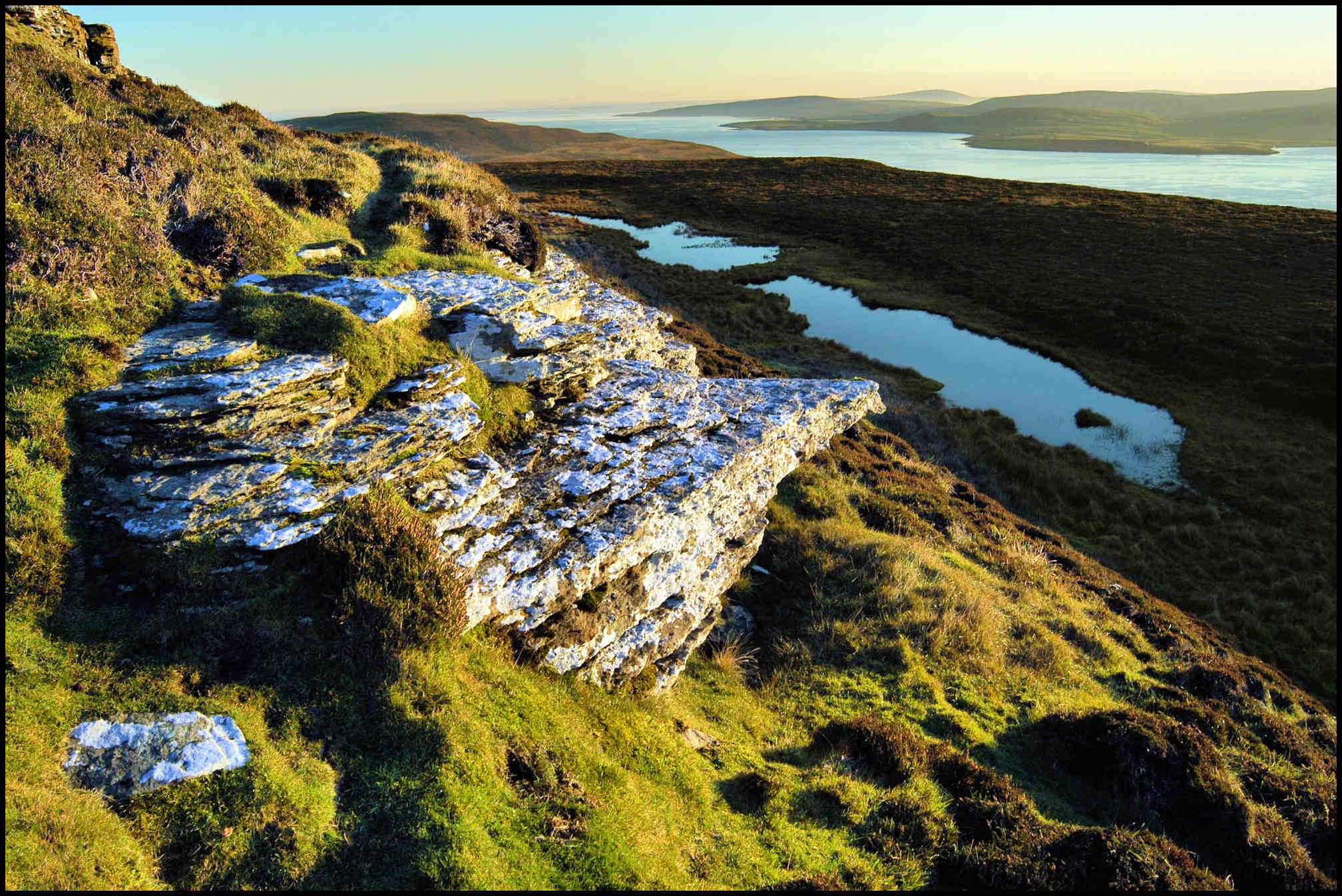
URADAY is a deep valley on the south-west slope of Ward Hill, between Cat Hill and the top of Ward Hill, above Westness. The water of the Loch of Uraday can be seen in the shadow of the hill in the photo above above.
VICARAGE LAND. There was some land in Knarston known as Vicarage land, of which, in 1503, the skats, or taxes, were drawn by the (Catholic) Vicar of Rousay. This land, represented by the later Rousay Glebe, came on record again over a century later.
At the time of the Reformation, Church lands which had not already been alienated otherwise, were annexed to the Crown, and many years were to pass before all Protestant ministers received adequate provision of manses and glebes. After a time, Acts of Parliament did make provision of a sort, but that was slow in being put into effect.
On May 1st 1626, it is recorded that George Grahame, Bishop of Orkney and Zetland, “compeared upon the ground aftermentioned,” and “with advice of Magnus Craigie in Skaill, Rolland Ingisger in Brugh, and Hew Craigie there, three honest and godlie men of yle and parochine of Rousay, market, designit and appointed to Mr. David Watsone, presently minister actually serving the cure at the Kirkis of the yles of Rousay, Egilsay, Wyre and Inhallow – All and haill the Threepenny land of auld callit Viccaris Land in the toune of Knarston with the house biggit thairupon, sumtyme pertaining to the viccar of the sd yle of Rousay, presently possesst and occupyit be Edward Alschunder…..to be ane mans and gleib for the said Mr. David Watsone.”
And there a manse and glebe were situated for many years afterwards.
WALLHOUSE is the name of a vanished house in Sourin. On December 1st 1817, Archibald Sinclair in Swandale “66 years of age come the 1st of May next,” giving evidence in a lawsuit, declared he was born at Wallhouse “in the neighbourhood of the Manse that is in Sowrick.” The actual site is unknown, but probably somewhere near the Well of Oro at Knarston.
WEDDINGS. Long ago, travel within an Orkney island, and between neighbouring islands, was much more difficult and therefore less frequent than it is today. Consequently, marriage partners were sought from within the island, often from within the same district. A degree of inbreeding in the population resulted from this but down through the generations there was an awareness of the problems that could arise. Marriage between first cousins was frowned upon and discouraged especially if the families concerned were aware of some weakness on one or both sides. However, this atmosphere of disapproval of such marriages did not prevent some taking place but the arrival of new blood in the island from time to time prevented any serious problems arising.
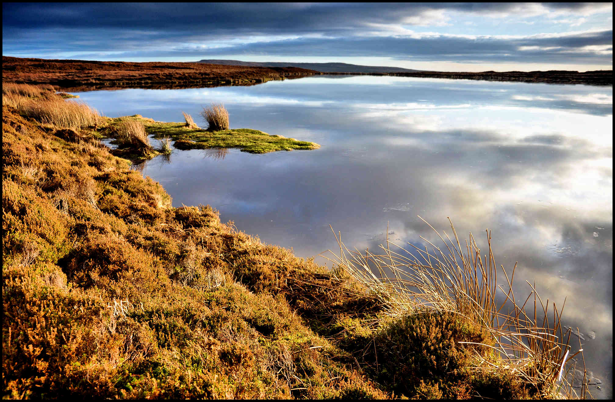
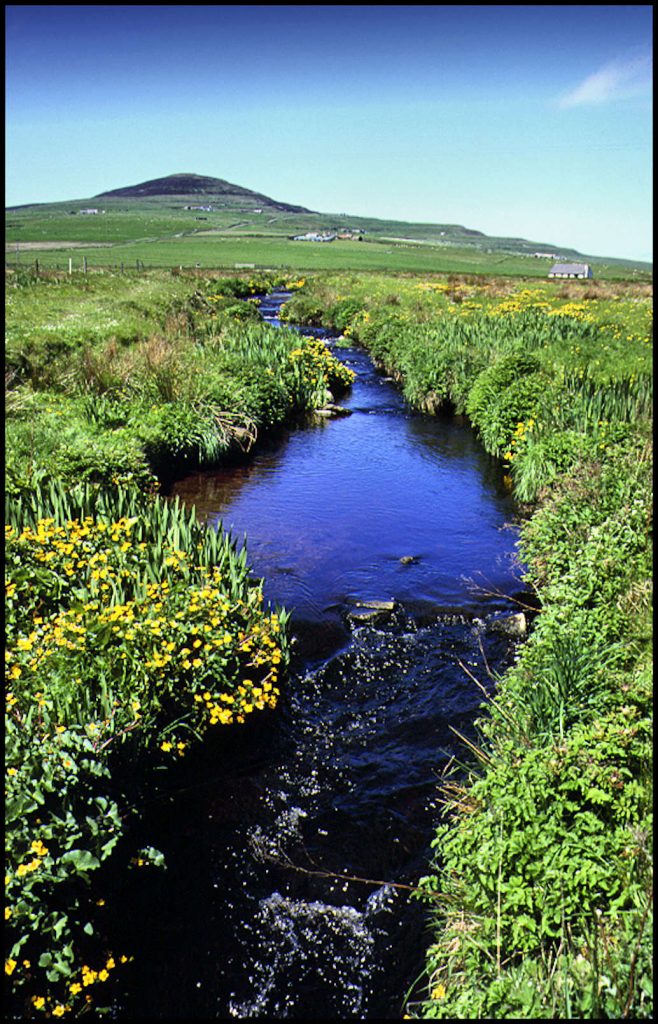
Until about 1930 a wedding in Rousay usually took place in the barn at the home of the bride. A meal would be provided in relays in the house for all the guests. If the wedding took place in the summer time the younger people would pair off and, preceded by a fiddler or a piper, would set out for a walk with the bridal party at the head of the column. In Wasbister, the walk went round the loch, pictured above, a distance approaching two miles. By the time they had returned, the older guests would have finished their meal and the walkers sat down to theirs. The celebrations usually went on all night and the weary dancers would wend their way home as breakfast time approached.
Farm weddings went out of favour as church weddings became more popular, but the reception was still held at the bride’s home after the church ceremony. Before long it became the common practice to have the wedding in the church and the reception in the local hall. Couples who preferred a simpler wedding could be married by the minister in his manse or could choose to have a civil wedding ceremony in Kirkwall.
WELL OF EASE was the name given to a fresh-water spring that bubbles up on the beach below Langskaill. Its origin is obscure; it is only a few hundred yards along the beach from the site of the ancient Colm’s Kirk – a ruinous chapel site of Celtic foundation, possibly dedicated to either St Colm or St Columba.
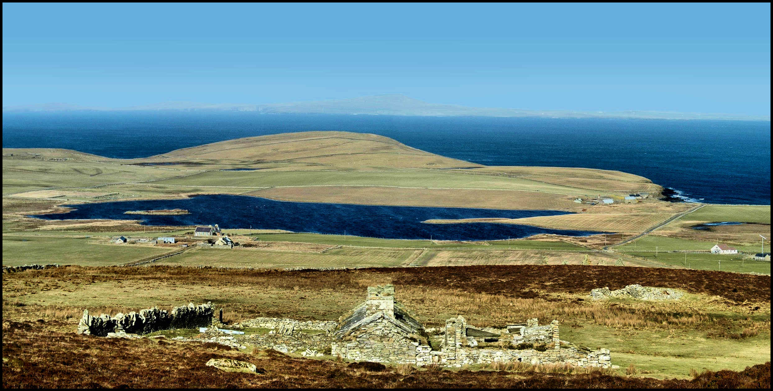
WESTSIDE. The Westness area of Rousay has been described as ‘the most important archaeological mile in Scotland,’ for it spans settlements from the first Stone Age farmers, the Pictish Iron Age, the Viking invaders, the period of the Earls of Orkney, through to the mid-19th century clearances when 210 people were evicted from Westness and Quandale by the laird, George William Traill.
A mile after leaving Wasbister the road turns southwards around the shoulder of Mansmass Hill. From here there is a splendid view over Quandale and its deserted crofts and across the Sound to the island of Eynhallow and beyond to Costa Head on the Mainland. It was from this point that the old track that came by Kirkgate in Wasbister and over the hill led in a straight line down the slope to the kirk of St Mary at Skaill, standing on the shore facing Eynhallow.
Robert Craigie Marwick told of an incident that was supposed to have taken place at this point on the track a long, long time ago, in the days before there was a proper road running round the island. An old woman had died at one of the small crofts on the Wasbister hillside and she was to be buried in the Westside kirkyard beside her late husband. It was a warm summer’s day and the men who were carrying the coffin in relays were feeling hot and uncomfortable in their heavy home-spun suits after the long trudge over the rough track. They decided to have a short rest before descending the hill to the kirkyard. The coffin was set down and the men sat down to catch their breath. As they sat there talking they heard a knocking sound coming from the coffin. They looked first at it and then at each other unable to believe what they were hearing. Then the chief mourner, quicker thinking than the others, responded to the ever increasing volume of knocking by taking out his knife and starting to prise up one of the boards that formed the lid of the roughly made coffin. Within a few minutes the whole lid was off and the old woman sat bolt upright and looked about her. When she realised that she was witnessing her own funeral she leapt up, grabbed one of the boards of the lid and started to lay about her like someone demented, shouting, “Ah’m no deid! Ah’m no deid!” That fact was plain for everyone to see and no-one felt inclined to dispute her claim, especially while she wielded the piece of wood. The hapless mourners kept their distance until the poor woman calmed down. After a hurried conversation with the chief mourner she agreed to resume her seat in the coffin. She was conveyed back to her home amid much banter and good cheer.
When the company reached the old woman’s cottage the coffin was set down at her door and she was helped to her feet. She turned to the chief mourner and said, “Next time thoo taks me tae the kirkyard I want thee tae stop at the sam place as thoo did the day. I want thee tae deu that even if hid’s poorin wae rain. Juist tae mak sure, thoo kens. Aye, juist tae mak sure.”
That instruction was complied with a few years later, but on that occasion no knocking was heard and the journey continued down to the kirkyard at the shore.
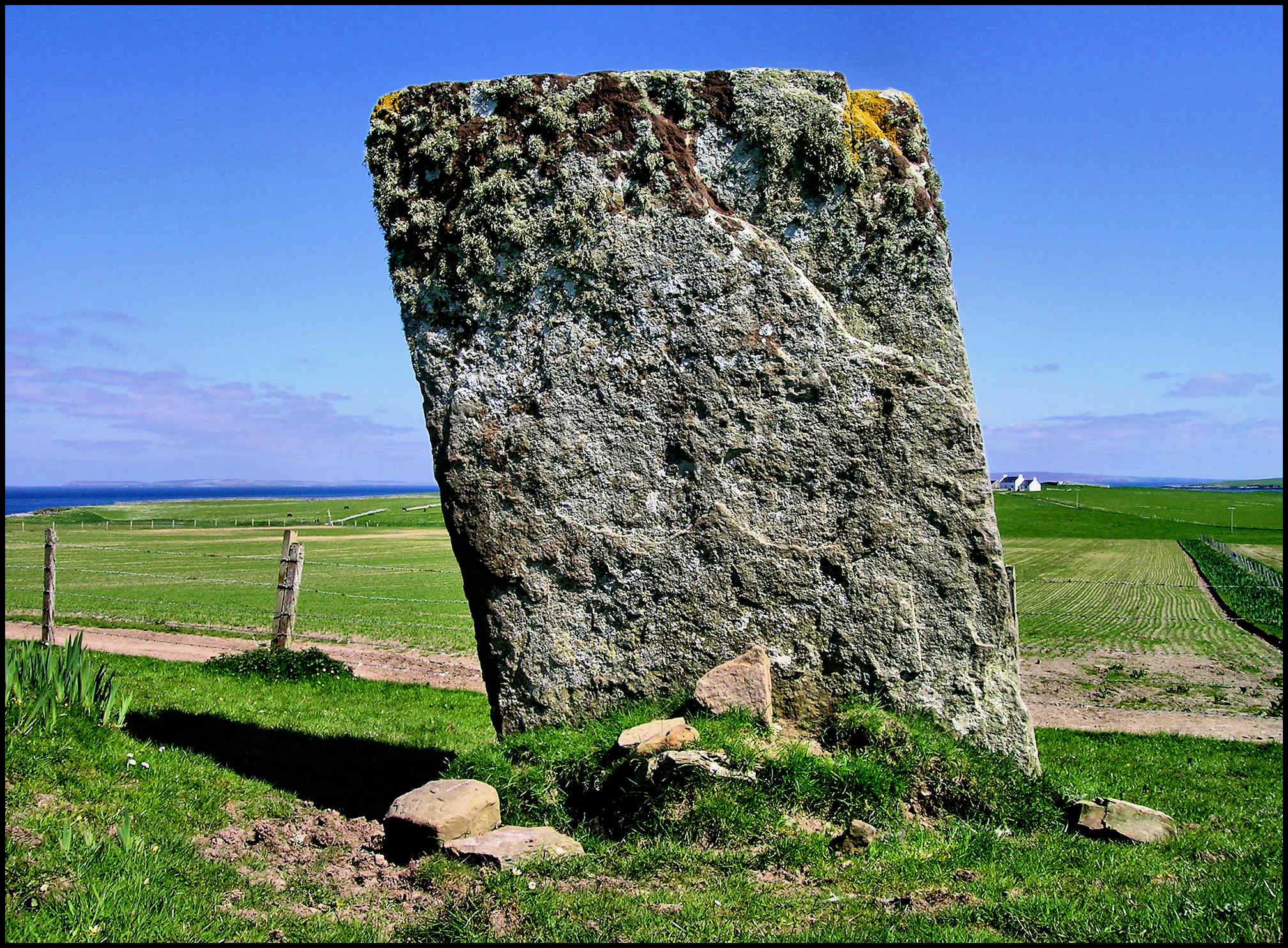
YETNASTEEN. Standing stones are a feature in many parts of the Orkney landscape – long slabs of rock standing upright in the ground. Some of them are in groups, the best known of which is the Ring of Brodgar in the parish of Stenness on the Mainland. It originally had about 60 stones of which 27 still remain standing, many to a height of ten feet or more. Rousay has some standing stones though none as tall as those at Brodgar.
One of them stands on the land of Faraclett. It is called the Yetnasteen, a name derived from Old Norse meaning ‘stone of the giants.’ It is a large slab of rock about three feet wide and ten inches thick standing about seven feet high. One cannot but wonder why and how these huge slabs of rock were put in place in many parts of the Orkney landscape. Vast numbers of people must have been marshalled to move and erect them. It is easy to envisage these monoliths, especially if seen in the last rays of the evening light, as silent sentinels standing guard over the surrounding countryside, and it is little wonder that, in some people’s minds, they came to be invested with unusual powers.
It is said that in the early hours of every New Year’s Day the Yetnasteen takes two giant strides down to the nearby loch for a drink. There are even those who claim to have witnessed this but somehow their accounts of the event always seem to lack the clarity necessary for them to be credited with any significant measure of accuracy. Something to do with the celebratory time of year no doubt!