THE FIELD NAMES OF ROUSAY
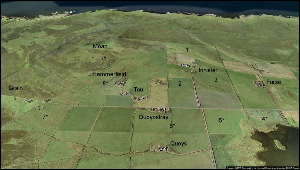
WASBISTER
1. Knockha’ 2. Gorn 3. Hammer
[Thanks to Alistair and Muriel Marwick, Innister, for these names]
4*. Longaness 5*. Kuiv 6*. Meeran 7*. Hill Park 8*. Berry Brae
[All starred field names in this and subsequent images were supplied by a member of the
Rousay, Egilsay and Wyre Community Council Local History Project, carried out in 1982]
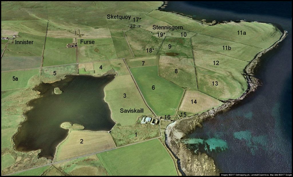
SAVISKAILL – SKETQUOY – STENNISGORN
1. Mill Meadow 2. Breekness 3. Lower Bregaday 4. Corse Kirk 5. Longaness
5a. Kuiv 6. Upper Bregaday 7. Long Leys 8. Fal Quoy 9. Meadow Park
10. Grithin 11a. The Head (outer) 11b. The Head (inner) 12. Switzerland
13. Baterass 14. Conquoy 15. Nort Hoose 16. Backyard
[All Saviskaill names supplied by Athol Grieve]
17*. Nortby 18*. Hoosen 19*. The Grange
[Hugh Marwick’s Place Names of Rousay also mentions Husmasay, Lamiger and Swanaland at Sketquoy,
and Fauld at Stennisgorn, but exact locations are unknown]
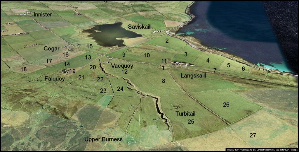
LANGSKAILL
1. Horsepark 2. The Sands 3. Byre-sheid 4. The Nine Rigs 5. Ourin
6. Cooper’s Meadow 7. Lee 8. Knowe o’ Djue 9. North Toon 10. West Toon
11. Stackyard/Mill 12. Vacquoy 13. Nedyar 14. Lowshoose 15. Maybank
16. Lower Skuni 17. Upper Skuni 18. Heatherha’ 19. Chalmers’ Rig
20. Hungry Quoy 21. Seatter’s Quoy 22. Claybank 23. Middle Park
24. Castal 25. Turbitail 26. Flotty 27. Whitemeadows
[All names courtesy of Jo Inkster, Langskaill, and Ed Firth. Nedyar]
SOURIN
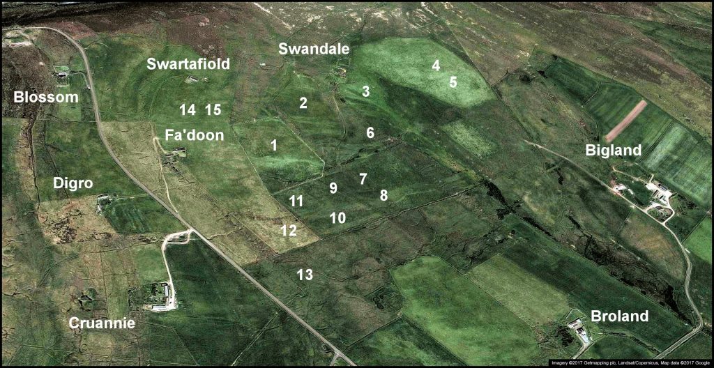
FA’DOON, SWARTAFIOLD, SWANDALE
Field names supplied by Alan and Ingrid Grieve
1. Mugley 2. Girsequoy 3. Assifiold 4. Nortoon 5. Skellamurry
6. Langquoy 7. The Meadows 8. The Sooth Meadows 9. Lower Geord
10. Middle Geord 11. Upper Geord 12. The Trepshead 13. Hungryquoy
14. The Upper Roondo 15. The Lower Roondo
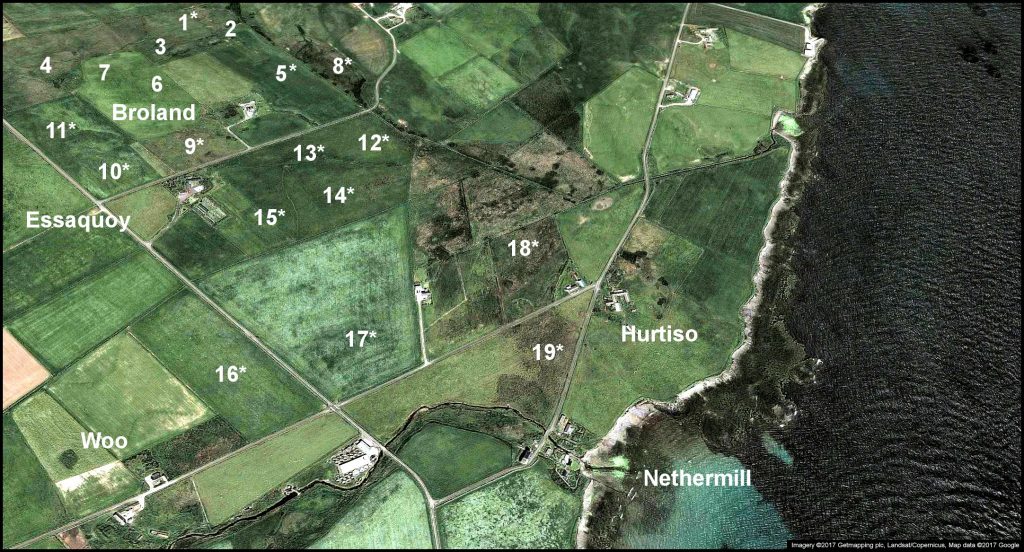
BROLAND, ESSAQUOY, HURTISO
Field names supplied by Tommy Gibson and Alan Grieve.
Those marked with * are from the 1982 Rousay, Egilsay & Wyre Community Council History Project
1. North Field 2. Meadow 3. Grit o’ the Nort’ Green 4. Hungryquoy
5. The Middle Field 6. The Dam Field 7. Houseby 8. The Brecks 9. Fananoo
10. Cuppo 11. Grindlays Breck Park 12. The Jib 13. The Minister’s Pow
14. The Meadow 15. The Well Field 16. The Longsheet 17. Husbae
18. Howdis Meadow 19. The Bowsprite
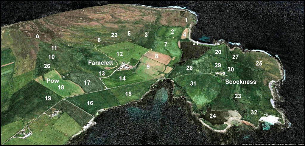
FARACLETT
Field names, courtesy of Fred Garson and Laura French
1. North Park (Birdie Field) 2. New Park 3. Middle Hill 4. Mugly 5. Rabbit Field
6. Kissed Rig 7. Field above the Loch 8. North Meadow
9. Field below the Steading 10. Back of the Swine Park [swine pronounced swinee]
11. Mirpha or Mirthve 12. Neo 13. Mount Rascal 14. Field below the Cottage
15. South Meadow 16. Field below the road of Pow 17. Field at the back of Pow
18. Field at the front of Pow 19. Cuppo [Myres] 20. Sandsheet [Scockness]
21. The Ayre of Faraclett 22. The Taft 23. Hilter Sharn [Scockness]
24. Salt Water Loch [of Scockness] 25. The Ness [Scockness] 26. Tattie Plot
A – The fence that goes through Faraclett Head with a dog-leg angle in it
was erected by SNH in the 1980s.
Scockness field names below supplied by Bruce Mainland
27. Bow Geo 28. Freshwater Loch Field 29. Byre Field 30. The Gubs
31. Home Field 32. The Links
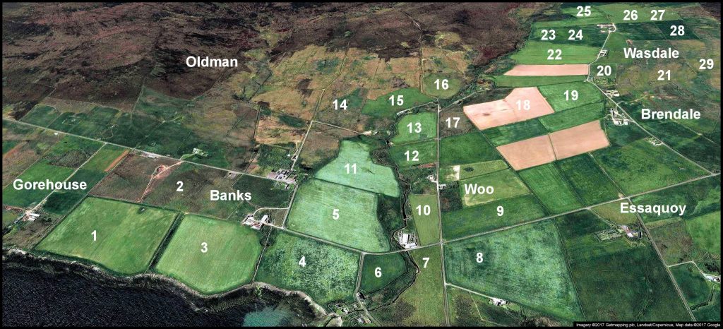
BANKS, BRENDALE, WASDALE
Field names supplied by Eric Shortland
1. Finnio 2. Hill Park 3. Below 4. Mill Park 5. Roadside 6. Mill Brae 7. Volespreed
8. Houseby 9. Longsheet 10. Crossroads 11. Co-op Stable 12. Backyard
13. Quattro 14. Outerdykes 15. Faroe 16. Manse Field 17. Heather Park
18. Tirlot 19. Ervadale 20. Well Park 21. Hill of Wasdale & Ervadale
22. Wasdale 23. Heatherhouse 24. Curquoy 25. Lower Gripps
26. Upper Gripps 27. West Crea 28. East Crea 29. Feelyha
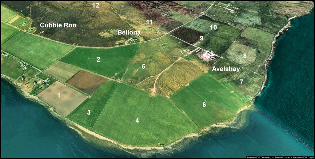
AVELSHAY
Field names supplied by Sinclair Taylor
1. Cott Mowat 2. Sheepy Park 3. Peedie Park 4. Enquoy
5. Lower Classiquoy 6. Heathery Park 7. Above the Boat 8. Far Watter
9. Above & Back o’ the Hoose 10. Above & Front o’ Cruar
11. Peedie Hill 12. Glifter
THE BRINIAN
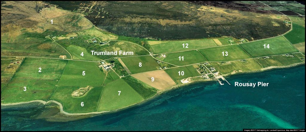
TRUMLAND
Field names supplied by Eric Shortland
1. The Hass 2. Upper Geord (Rock Ridge 2) 3. Lower Geord 4. Dishans
5. Rock Ridge 1 6. Taing 7. The Meadow 8. Green Field 9. Burn Field
10. Pier Field 11. Monument 12. Daisy Field 13. Viera View 14. Brinian
FROTOFT
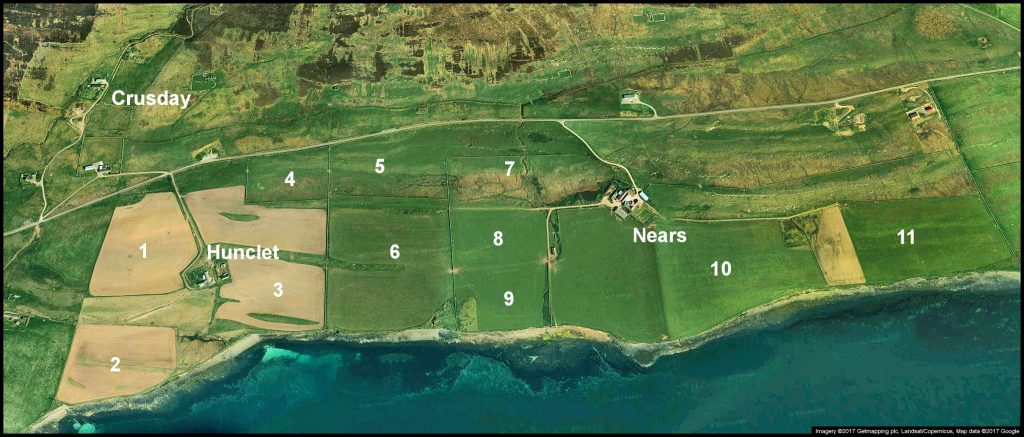
NEARS
Field names supplied by Robert Mainland
1. Breckan 2.Varmady 3. Nether Hunclet 4. Geord of Hunclet
5. Lower Hill 6. Mount Rascal 7. Damm Field 8. Mill Sheed
9. Knowe Field 10. Myers 11. Geord of Nears
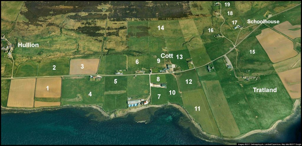
FROTOFT FIELD NAMES
1 – 14 supplied by Bruce Mainland – 15 – 19 by Olive & Billy Kemp
When the Frotoft ‘numbered’ houses were built they were all allocated with 14-acre strips of land.
1. Lower Hoose 2. Upper Hoose 3. Outer Quoys 4. Breek 5. Burrian
6. Brough 7. Workshop South 8. Workshop North 9. Home North
10. Home South 11. The Point / Vassay 12. Tank Field 13. Maybank
14 The Hill Field 15. Breckan [Tratland] 16. Fauld 17. Playground
18. Park of Newark 19. Mid Cruseday [Mid Hoose]
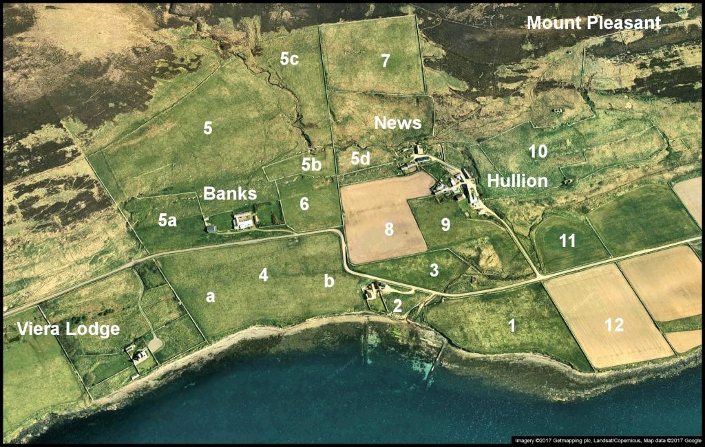
BANKS, NEWS, & HULLION
Supplied by Muriel Johnston, Thomas Sinclair & Bryan Inkster
1. Mayvie [Banks] 2. Owld Yard 3. Hookaly
4. Three Fields – a: ‘Next the Lodge’ – b: ‘Next Yorville’
5. The Hill Ground 5a. Minners
5b. The Gin Yard, named with reference to illicit spirit smuggling. There was a drinking
house over the dyke from Minners, near the well o’ Minners. Thomas adds: I believe
that the name Fairy Brae [the strip below Banks] was because there used to be an
ale house at Hullion. Patrons making their way home from there may
have had a vivid imagination – kindo like “Tamo Shanter” !
5c. Lunden 5d. Quoy o’ Cleuk 6. ‘Atween Us & News’
7 -12 supplied by Bruce Mainland
7. London 8. Home Field 9. Hullion 10. Lairo
11. Ouse 12. Mayvie [News]
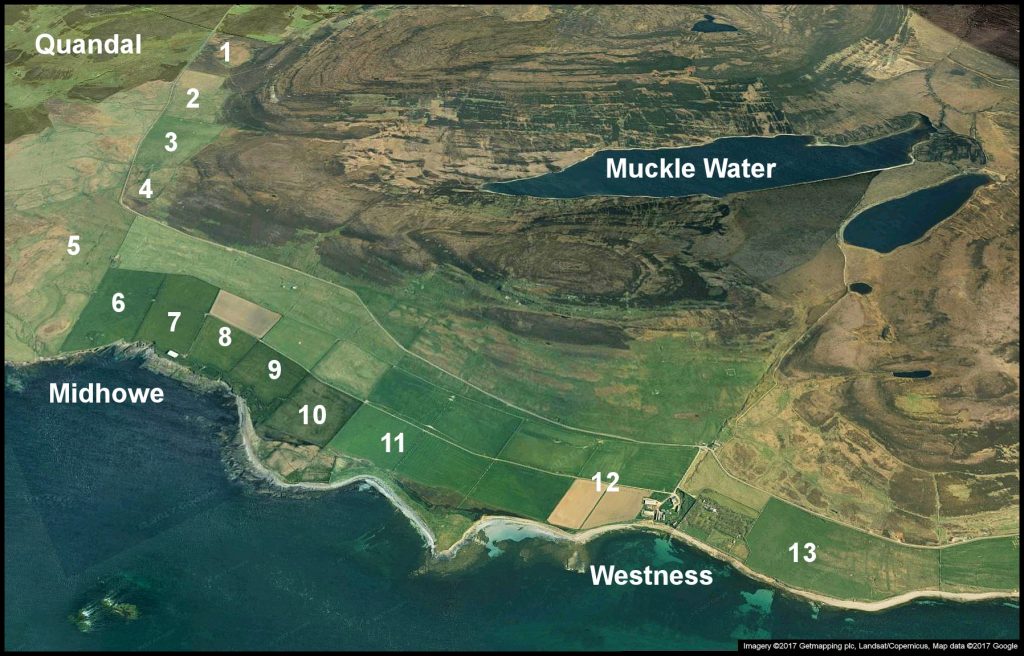
WESTNESS
WESTNESS FIELD NAMES
Supplied by Kathryn and Russell Marwick
1. Stourmira 2. Bonie-hole 3. Flinterquoy 4. School Park 5. Golf Course
6. Outer 7. Second Outer 8. Brough 9. Skaill 10. Fifth Field
11. Swandro 12 Home Field 13. Skae
Imagery ©2017 Getmapping plc, Landsat/Copernicus, Map data ©2017 Google
