Rinyo, Rousay, Part 2 Vol 81 1946-47 Society of Antiquaries of Scotland.
Proceedings Of The Society, 1946-48.
A Stone Age Settlement at the Braes of Rinyo, Rousay, Orkney.
(Second Report.) by Professor V. G. Childe, D.LITT., D.Sc., F.B.A., F.S.A.,
F.S.A.Scot., and WALTER G. GRANT of Trumland, F.S.A.Scot.
Read March 10, 1947.
I. Excavations.
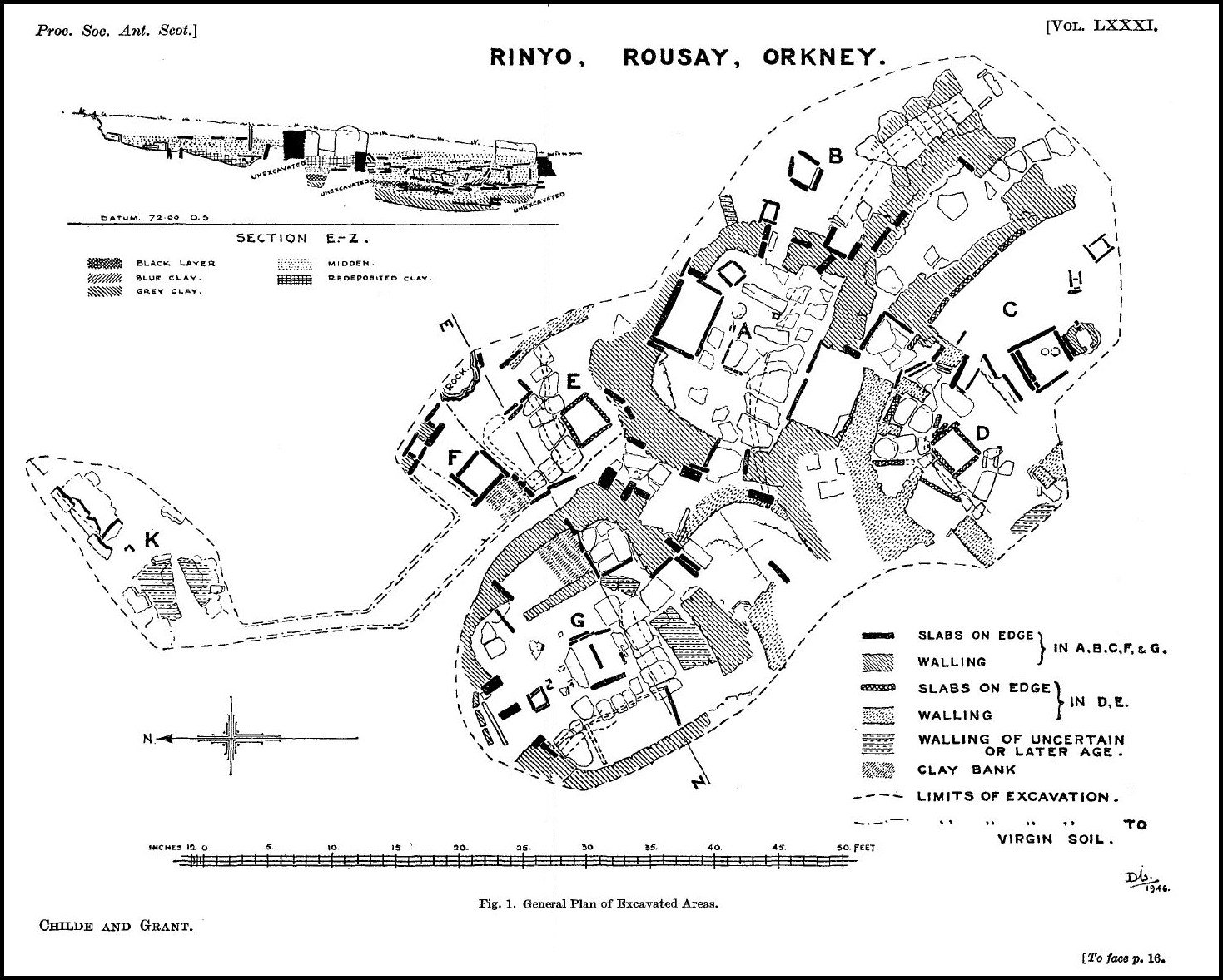
The operations of July – August 1946 were concentrated firstly on areas lying immediately north of dwelling A and, like it, nestling at the foot of the little cliff that shelters the settlement on the east and has helped to preserve it. In this direction the operation of the winter 1937-38 had exposed a hearth (F) and the door and bed of a dwelling (G). Then in the same summer part of a hearth (He) had been discovered under the casing wall of A, between A and F, and at the same time a segment presumed to represent the east wall of the assumed dwelling E had been identified. It was hoped by the removal of ruinous structures attributed to F to recover the north wall and other features of E. But these expectations were only partially realised (fig. 1, below).
In 1938 we had remarked that the 77- and 78-foot contours (plotted by extrapolation) swerved eastward over the area of E, and had treated this as a natural feature in the conformation of the land. It now appears that north of the assumed area of E these contours resume the same north-north-west trend as they exhibited over B and A, and as the 76-foot contour does everywhere. Moreover, the east wall of E turns out to be a mere skin-deep retaining wall; behind the facing course stood a slab on edge, and behind that virgin soil or pure hill-wash sloped up very steeply (Plate III, 1). Presumably, therefore, the east end of “dwelling E” had been excavated in the subsoil to a depth of at least 2 feet. No continuation of the wall, which had been traced in 1938 to a ragged break, was found. Just where the wall breaks off we found a socket-hole in the subsoil, over 8 inches deep, 10 inches long, and 4 inches wide; it had evidently held a slab or post set transversely to the line of the existing wall segment.
Under the area occupied by Hf a bank of yellow clay, full of fractured bits of rock and rather dirty, but archaeologically sterile, runs east and west over the virgin soil. It is taken to represent the filling of the north wall of dwelling E. On the east this material can scarcely be distinguished from the steeply sloping virgin soil, but farther west a thin black band, containing small scraps of pottery and bone, defines the frontier between the natural and the laid clay, and there is a bed of fractured slabs at the base of the latter. Along the southern margin of the bank is a rough wall of very small slabs that now forms one side of a drain channel. To the west the bank abuts against the north end of a pair of slabs on edge rising scarcely one foot above the floor of dwelling E, but presumably representing part of its west wall.
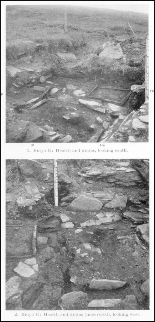
The chamber floor consists of virgin soil at the east end and elsewhere of midden, covered with a thin skin of yellow clay or with slate paving-slabs. On it the only surviving articles of furniture are the hearth, He, and a small box, P, to the north-east of the latter. He measures internally about 2 feet 6 inches square and is defined by four stout kerbstones, measuring respectively 2 feet 10 inches x 12 inches (S.), 2 feet 9 inches x 1 foot 4 inches (W.), 3 feet x 1 foot 5 inches (N.), and 2 feet 4 inches x 9 inches (E.). The east end of the north kerb is sunk 6 inches in virgin soil, and the east kerb and end of the south kerb also descend into it. A supplementary kerb, 1 foot long, strengthens the north kerb at its west end. The hearth was bottomed with a stout slab 2 feet 6 inches by 2 feet, trimmed along the south edge to fit the kerbs but leaving a gap at the north-west corner to communicate with the drain. On it lay 10 inches of peat ash in which three black layers could be seen in section.
The floor immediately north of the hearth is paved with slates for 2 feet, and these slabs, actually covering drains, extend also 3 feet east of the hearth at the north-east corner (Pl. III, 1). Beyond these but only a foot in front of the east wall two slabs project 4 inches above the natural clay floor to form two sides of a shallow box P, the west side of which is extended northward by a third slab that scarcely emerges from the subsoil. The east and north ends are missing. Between the uprights were three layers of horizontal slabs, with clean clay between and around them. The uppermost had ‘a maximum width of 1 foot 8 inches and a length of 3 feet; the two lower layers were composed of superimposed halves of a single slab, shown by the impression burnt on it to have previously served as the base for an oven like the slabs discovered in A and C during 1938. The lower half lay directly on virgin soil.
The dwelling floor was traversed by three drains running under the pavement slates (Pl. III, 2, above). One begins under the east wall, presumably to carry off the water that exudes abundantly from rock-beds and flows down the cliffs after heavy rain. It runs north-west to join, just north-east of the hearth, a second drain. This starts at the shallow box P, and passes along the north side of He to debouche into a third drain running north and south, past and partly under the west kerb of He. It was very neatly constructed with trimmed slates set obliquely to converge and form a V-shaped channel6 inches deep. It appeared to start under the bank of clay, 6 feet north of the corner of He, emerging from beneath a stout slab at the margin of the bank and eventually flowing out southward in the direction of A. Just after emerging from the bank this drain is joined by another east-west drain which, as already mentioned, flowed along the south margin of the bank at a distinctly higher level than the north-south channel. Its northern margin was a rough two-course wall, while the south side was formed of the usual tilted slates. This drain starts explicitly in an irregular hollow scooped out of the clay just north-west of box P. But a channel, running along the west side of that box from the south, seems to communicate with this depression. It looks, in fact, as if the drains running along the north side of He had become blocked and their contents had been diverted by this circuitous route in the direction of the main north-south channel. For there was a second layer of slates over the pavement east of He but high enough to leave a channel under them.
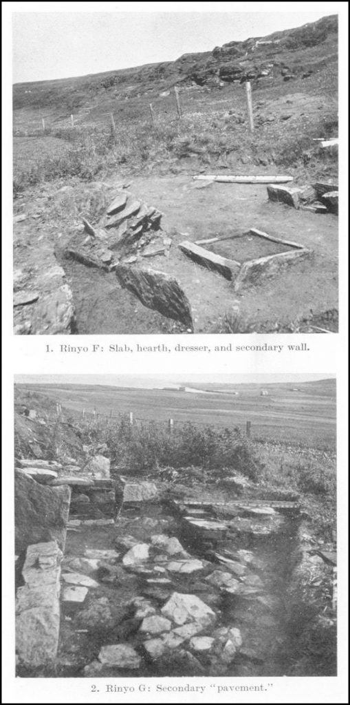
The floor of F had been disturbed, and its walls are altogether missing save perhaps for some slabs over He. Eight inches above the latter’s west kerb is the base of a slab on edge, 16 inches high and 21 inches long. This together with pillar-stones on either side of it may have formed the back to some construction in dwelling F. On its north side a series of stout slabs, at 17.10 *, extend for 3 feet northward in the direction of Hf. Beneath them are 8 inches of midden packing, then some thin slabs, and then clay to the floor of E at 15.65. But the topmost set of slabs cover a slab on edge that looked as if it ought to belong to the series that runs west of Hf and appears contemporary therewith. The floor of F when uncovered in 1946 was so much disturbed that it was impossible to decide whether the slabs over He and the walls they support belonged to F or to some subsequent construction. A layer of yellow clay that covers the former E area at an average level of 16.40 from the outer wall of G to the rock-face on the east is the foundation rather than the living floor of F, and underlies the hearth and dresser, the only intelligible remnants of the dwelling’s former furniture. [ * The levels in these Reports are referred to an arbitrary datum 65.30 feet above Ordnance Datum].
Hf, formed of four stout kerbs about 9 inches high, is set on the top of the clay bank mentioned in connection with the north wall of dwelling E. It measured internally 2 feet 8 inches by 2 feet 4 inches and was filled to 17.25 with red ash. It rests on a thick bed of yellow clay above the dirtier clay of the bank and a slate slab to the north. In the clay base we observed an oval depression extending from the centre to the north-east corner, but only 3 inches deep.
Only 3 feet east of this hearth two piers of a dresser rise 1 foot above the clay floor. They are represented by stout slabs on edge that face built walls of the same height projecting 1 foot 2 inches. The back of the recess between these piers is formed by a slab on edge rising to the same height. A second similar slab to the south must have formed the back to the second recess. The southern pier, that should have bounded it, is missing, and may have been partly constituted by a projecting outcrop of bed-rock. Immediately behind the slabs undisturbed soil rises in a steep slope from the floor-level about 17.50 to the top of the rock-shelf at 19.90 in 3 feet behind the back slabs.
Opposite the dresser, and about the same distance west of the hearth, ran a line of slabs on edge. The highest, 3 feet 6 inches long, on its upper edge rises to 18.05, some 15 inches above the clay of the floor. Its base rested on the slabs paving E just above the drain. The next slab to the north disintegrated between 1937 and 1946. In that year we found a third slab, j, in the same line, 2 feet long and 1 foot 6 inches high. Its upper edge at 16.35 seems to limit the clay floor in that direction.
The back of the wall of dwelling G, that is still intact to a level of 17, may have formed the front wall to house F, unless that were earlier than G. Immediately north of Hf, however, begins a ruinous wall, running north-north-west, the base of which is 17.85, well above the floor-level of F. It was faced to the east and has tilted back bodily westward (Pl. IV, 1, right). It could once have served as a casing wall to G.
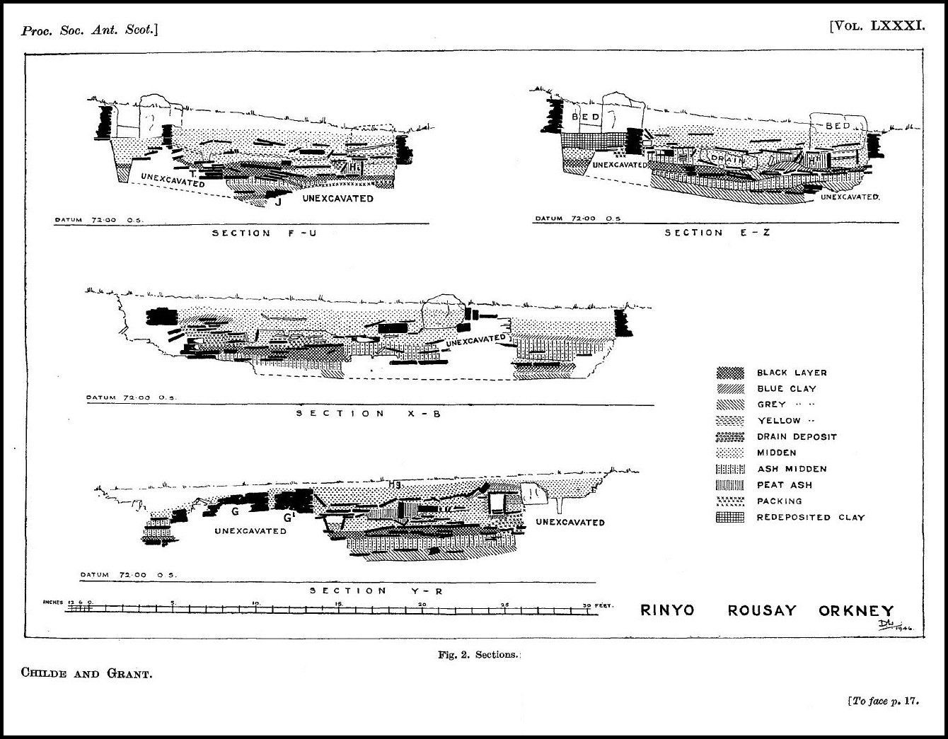
Dwelling G. – In 1937-8 the doorway of a dwelling opposite and north of the door of A had been observed, and the south-east corner and right-hand bed of this chamber had been cleared down to the floor-level. The whole area was systematically excavated in August 1946. Although situated under a ploughed field, the complete circuit of the walls was recovered save for a break in the south-west corner. On the west the wall-tops emerge into the tilth and actually show dints from the ploughshare, yet they were found standing to a height of 15 to 18 inches from the floor. The east end, in land not recently cultivated, is in better condition; the walls stand 2 feet to 2 feet 6 inches high and individual uprights still higher. The whole walled area west of the door and bed was filled to the wall-tops with a deposit of reddish soil or midden containing ashes, burnt bones, pottery, and Skaill knives, but very few flints. This deposit extended northward even beyond the dresser and the outer face of the wall behind it. Its surface sloped down across the chamber from 16 on the north to 15.5 on the south, and from 16 at the bed-front to 15.25 over the west wall. Against the piers of the dresser and in the recesses between them, as in the north-east corner, were piles of grey clay very tightly packed (fig. 2 XB and YR, below).
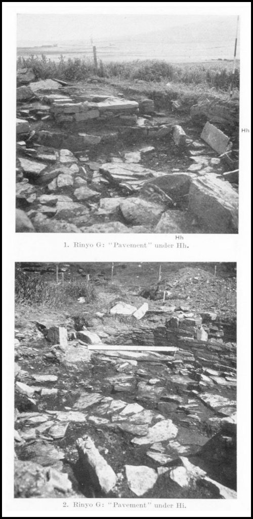
Pots were found standing in the midden at several levels but the succession of “floors” was rather vague. A layer of grey ash poor in relics seemed on the eastern side (that is for the first 6 or 7 feet west of the bed) to separate an upper occupation level (8) from a lower one (7) the surface of which sloped from 15.3 to 15.15. Sherds of four vessels decorated with a lozenge pattern were found exclusively in the upper deposit. The grey ash, however, hardly constituted a floor. The deposit below it rested on a very irregular and rather discontinuous “pavement” of thin slabs (Pl. IV, 2, above). Few of these were strictly horizontal; quite a number were found leaning up against original structures rising above the dwelling floor such as the bed-front and the erection termed “wall G’.” Between and under such tilted slabs, bones of cattle and sheep and potsherds were preserved. No hearth or other fitment was found upon these slabs, but they completely masked the original furniture of the dwelling. Only on their removal was its original lay-out manifest. It is indeed not unlikely that the alleged pavement is nothing more nor less than the collapsed roof of that dwelling.

Chamber G (fig. 3, above), in contrast to the prevailing practice at Skara Brae, is entered through its longer side; it is, in fact, broader than it is long! It measures 15 feet from the south wall beside the door to the central pier of the recessed dresser, but 18 feet 3 inches across the beds. The corners of the east wall are as usual rounded. In the north-east corner, though the wall is only 18 inches high, the usual corbelling produces an overhang at the ninth course of no less than 9 inches! The south-west corner has, been broken away, but the west wall makes a distinct, if slightly obtuse, angle with the north wall, and is not bonded into it as far as the masonry survives; the junction is plugged with yellow clay (Pl. VII, 2).
The door is set some 18 inches right of centre in the south wall (Pl. V, 1). It was apparently of type i (Skara Brae, p. 13), but only the right-hand jamb and cheek are intact. The cheek is faced with a slaty slab that is preserved to a height of only 1 foot 10 inches, but enough to show half the hole for the bar that had been cut through it. A stout slab on edge set athwart the passage opposite in line with the jamb may be taken for a secondary threshold that would correspond with the slab layer (7) over the chamber.
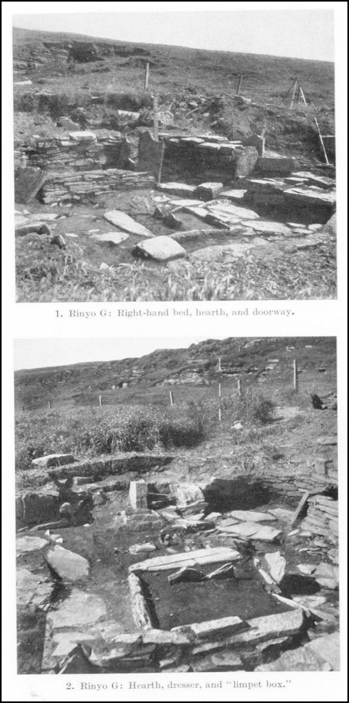
The right-hand bed is recessed into the east wall, 1 foot to 1 foot 6 inches, as in chamber A (Pl. V, 1, left). Its front is formed, not by a kerb, but by a wall of rather thin slabs, now 6 feet 6 inches long and 10 inches to 15 inches high. The south bedpost or headstone is a fine slab nearly 2 feet 6 inches wide and standing over 3 feet high above the floor. Between it and the upright facing the end of the recess is a gap about 1 foot wide partially closed by a slab on edge scarcely 1 foot high. The north bedpost was found leaning southward against the end of the bed-front with its base 1 foot away or 7 feet 6 inches from its southern counterpart. It is only 2 feet 3 inches high and 2 feet 4 inches wide along its upper edge, which alone impinged against the dwelling wall. Its base is only 1 foot 9 inches wide, so that there was a gap nearly 7 inches wide and 18 inches high between the slab and the wall. This bed was not paved, but its floor seems to have been raised 1 foot above that of the rest of the chamber by a deposit of dirty but archaeologically sterile clay, very similar in texture to the clay bank north of E and quite possibly an actual continuation of that.
The left-hand bed, 7 feet long and 3 feet 6 inches deep, was built out from the wall and framed with slabs, again as in dwelling A. It had however collapsed, and its fallen walls were completely covered by the slabs of the secondary “pavement.” The south headstone, 3 feet 6 inches long and 2 feet 3 inches high, had first fallen out southward and was actually found leaning against the broken end of wall G’. The front kerb, 7 feet long and just over 1 foot high, had then fallen inward over the headstone’s base. Finally the north headstone, 3 feet. 6 inches long and nowhere over 2 feet high, had fallen inwards covering one end of the kerb (Pl. VI, 1). The floor was probably paved with slabs that had largely disintegrated.
The central hearth (Pl. V, 1) is just over 3 feet wide by 3 feet 6 inches long. Only the east and west kerbs are formed of slabs on edge: That on the west measures 3 feet by 4 inches by 7½ inches high. The eastern one is represented by three sections now no more than 5 inches high. A horizontal slab 1 foot wide and 4 inches thick bounded the hearth on the north. A similar slab took the place of the south kerb for 2 feet 4 inches, but a kerb-stone occupied the westmost foot. Outside the east kerb a thin slab on edge rises 11 inches from the clay floor and runs parallel to the original kerb for 18 inches northward from its centre. Just at this point a kerbstone, 2 feet 4 inches long and 14 inches high, is set across the hearth (Pl. V, 2). Presumably these two stones represent a secondary version of the hearth. Actually the deposit of red ash was deeper north of the transverse kerb and spread over the prostrate north kerb of the original hearth as shown in section YR. Yet the slabs of the later “pavement” rested on the edges of the two secondary kerbs.
The dresser must have been recessed into the north wall, but only the three pier ends survive (Pl. V, 2). That on the east projects 4 inches south of the line of the wall and may have fallen forward. The eastern recess is 6 inches narrower than the western. The topmost layer of midden extends right across the dresser’s piers, but the clay below is interrupted by a slot, nearly 4 feet long, 4 inches wide, and 9 inches deep, that evidently once contained a back slab to the dresser standing some 2 feet behind the front at the centre pier. Six inches farther north stood two or three courses of the rear wall, faced to the north only.
Between the hearth and the dresser is a box, framed by four slate slabs. The box, not strictly rectangular but rather diamond-shaped, is in all 1 foot 2 inches deep, but there was a false bottom about 11 inches below the rim. The east and west sides were formed of two slabs the inner of which rested on the false bottom, while the outer, like the north and west walls, went down the full 1 foot 2 inches. In the middle of the upper edge of the north side a semicircular notch about 1 inch across and ½ inch deep had been chipped. The box was luted all round outside with a ½-inch layer of yellow clay right down to the slate that forms the floor. The bottom was formed of a stout slaty slab, found cracked but originally measuring just over 2 feet square, its corners having been carefully rounded. In it is a shallow depression 1 foot 3 inches by 1 foot 6 inches like the oven bases found in A and C but diamond-shaped like the box. The box was found covered by a large slate extending up to the dresser base and supporting the layers of blue and white clay attributed to the secondary occupation. Whether or no this slab itself be an original lid, the top of the box, rising to 15.40 above datum, must have emerged well above the original floor of G, here between 15.0 and 14.85 above datum.
West of it for about 2 feet were several layers of hard yellow clay within which was a bed ½ inch thick baked bright red at 14.20 but dipping to 13.90 at foot of dresser. It probably marked the site of a clay oven, but whether this belonged to G, to the earlier habitations represented by Hi nearby, or to the secondary occupation of the chamber could not be determined owing to the shallowness of the total deposit here.
An abnormal feature in chamber G is the construction termed wall G’ interposed between the hearth and the south wall of the dwelling (Pl. V, 1). It has the appearance of a built wall extending 5 feet westward from a point 3 feet in front of the left-hand corner of the entrance. Here it stands 18 inches or three courses high, and is concave to the north like the dwelling wall proper. The west end is a ragged break, but opposite the doorway it ends in a straight face two courses deep, but after a gap of 2 feet its line is resumed by two foundation-stones extending to the south corner of the right-hand bed. The base of this wall is about 4 inches lower than that of the south wall of the dwelling and it is over 2 feet thick. There is a gap between it and the dwelling wall of nearly 10 inches opposite the west cheek of the door, but about 2 feet to the west the back slabs of G’ abut against the face of the G wall and continue so till G’ breaks off, though the two walls are nowhere bonded into one another as far as can be seen now. The reddish midden deposit filling the chamber was not observed over the top of wall G’, which rises into the recent humus, but filled the gaps between it and the dwelling wall near the doorway. The slabs of the secondary floor (7) were found leaning against it and completely covering its southern extension. Hence it existed when this “pavement” was laid down and the secondary deposits formed in the chamber area. The paving-slabs and lintels over the south drain do not run under it, and the yellow clay that forms the dwelling floor elsewhere extends only 1 inch under its face. It thus looks as if wall G’ existed when dwelling G was laid out. It gives the impression of the remnant of the wall enclosing an earlier dwelling that had been deliberately left in place when G was built, perhaps to serve as a bench. But it is hard to see how the good inner face of the latter wall could have been built up hard against the back of a pre-existing wall. Yet we shall see later that the back of the south wall of G itself is built hard against the face of an earlier wall.
The floor of dwelling G sloped down appreciably to the south-west. In the north-east and north-west corners it is defined by slates at 14.80 above our datum and in the south-east corner at 14.65. But the floor under the left-hand bed seems to be as low as 14.25 – 14.40, though here the decay of the collapsed bedposts and other slabs makes its precise definition difficult. Between the right-hand bed and the hearth the floor is formed of a thin layer of yellow clay that extends also north of the hearth towards the dresser and about a foot westward in front of the left-hand bed. In it, north-west of the hearth, is a triangular group of three post-holes, that at the apex being 8 inches square and 8 inches deep, the others only 2 to 4 inches across and framed with small stones set edgewise. Another triangular group of small post-holes, similarly formed, lay north of the hearth. One of the stones framing the central socket in the latter group has been artificially grooved on the face used to hold the post.
The clay floor is far from even. Just in front of the right-hand bed near its north end there was a bowl-shaped hollow, 2 feet long and 1 foot 6 inches wide and about 3 inches deep at its centre. There is another north-west of the hearth nearly 6 inches deep. Over this we found a flat, water-worn stone, some 18 inches square and 4½ inches thick, resting on midden above the clay floor (Pl. V, 1). It would have served well for a seat by the fireside, but also helped to fill up the depression. The latter depression was found to occupy the line of a drain; the other was found to occupy a space between the stumps of earlier walls, masked by the clay floor.
The south-east corner is paved with several layers of slaty slabs the lowest of which run under the dwellings’ wall. It is bounded by a shallow slab on edge in line with the bed-front. The north-west corner was also entirely paved with large slates. On these lay a large water-worn boulder, and beside it a freestone block rubbed smooth and slightly concave on one face. The slabs were found to cover a V-shaped drainage channel bordered by slates as under E (Pl. VII, 2). But here there are on each side two slates set so that the lower edges of all converge on the same line, but while there is barely a foot between the upper edges of the inner slabs in each pair, those of the outer ones are nearly 2 feet apart. The space between the slates was filled with a greenish material, almost certainly dung, which exuded from under the north wall and has stained the clay floor of the older dwelling, I, below. But the channel did not run out under the north wall, its end there being marked by a slate set on edge but sloping inward, between the last drain slates and the wall base. The channel was traced from here for nearly 5 feet in the direction of Hg, within which distance its bottom sloped down from 14.00 to 13.50. As will subsequently appear, the drain channel has cut into an earlier hearth, Hi, and disturbed its ash contents. The hollow in the clay floor north-west of Hg may be attributed to the decay of the drain lintels. The channel could not be traced further south. But from the front of the left-hand bed to within a foot of Hi there lay a series of paving-slates connecting with those that lintel the south drain to be described below. Though no built channel was found beneath these, they did not fit firmly on to the underlaying clay but covered a loose deposit of greasy earth.
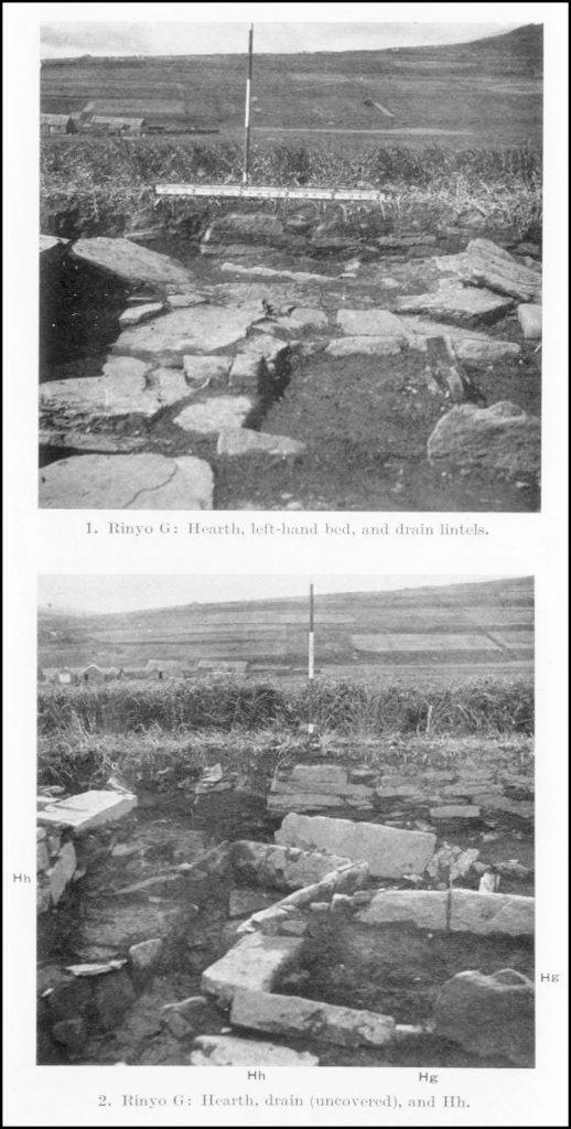
The whole area between Hg and the base of wall G’ and up to the left-hand bed was paved with heavy overlapping slabs, not covered by the yellow clay of the floor (Pl. VI, 1, right). The uppermost slabs covered and overlapped others. The whole complex roofed a channel, 16 inches wide at the top and9 inches deep, running from east to west downwards (P1. VI, 2). It started about 6 inches east of the gap in wall G’ and ran for 5 feet 6 inches west, its clay floor dropping from 14.80 to 14.00. Its end is a wall of three tiny slabs, 5½ inches deep (almost in line with the older wall T below it). The south wall is rather vague till after 6 inches west a tilted slab, transverse to its line, might mark the end of a branch channel under G’ which, however, could not be detected farther south. Thereafter the south wall is formed of three neatly trimmed rectangular slates, 9 inches high and set overlapping. There is a possible inlet from the south-east corner of Hg through the north wall which is composed of three slates, like its counterpart. The channel was lined with yellow clay laid over a bottom of slates till it ended in a sloping layer of grey clay. It led into an early hearth, Hh, the east kerb of which had apparently been cut through to make a channel for it, while the north kerb’s end is in contact with the channel walls. No discharge for drainage carried by the channel was found from the hearth unless it were along the “pavement,” layer 4, beneath it. But the channel contained only loose silt and gave no signs of exposure to heat on its walls or lintels. It is therefore more likely to be a drain than a flue. Perhaps, as suggested below, the discharge from this channel and that from the north drain were really allowed to seep down to the pavement-level and flow away between the loose slabs that composed its upper layer.
Deposits under the Floor of G.
Deposit 5. – Under the floor of dwelling G we encountered at least five earlier deposits. To Deposit 5 belong the two hearths into which the north and south drains led. (fig. 4, below). The south drain debouched directly into hearth Hh. It is as usual framed by four kerbstones; all are 8 to 9 inches high, the southern is 38 inches long, the western 30 inches, the northern 36 inches, but of the eastern only the southernmost 12 inches survive, the rest having been cut away to make the channel for the south drain of G (Pl. VI, 2). The top of Hh lies at 14 feet above our datum, vertically under the corner of the left-hand bed of G and covered by the slabs of its pavement.
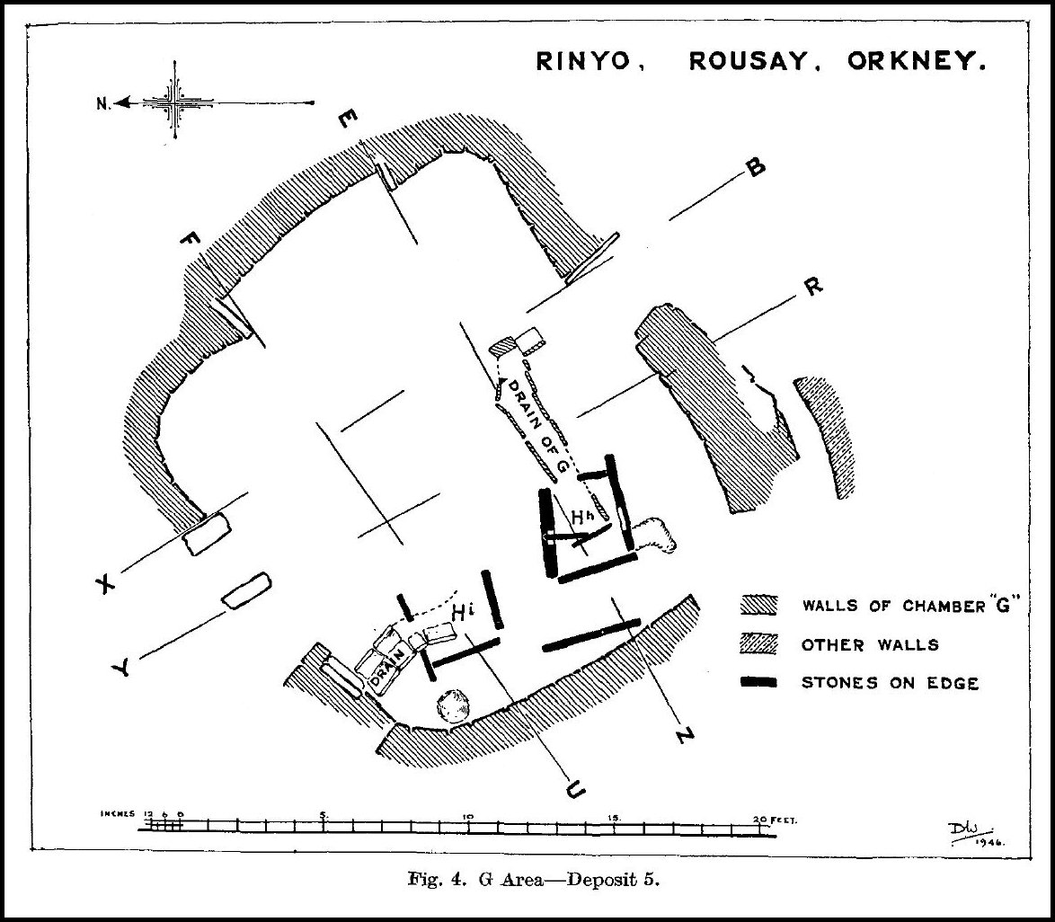
A slab that runs under the broken end of wall G’ overlaps the south kerb. So the hearth is older than both G and G’. A triangular notch, 5 inches deep, has been cut about midway along the inner face of the north kerb, and a similar, but rather shallow, notch was cut opposite to it in the south kerb (Pl. VII, 2, left). The notches were apparently designed to accommodate two triangular slabs which were actually found set across the hearth, the edge of one rising fully 4 inches above the top of the adjacent kerb, though neither reach the base of the hearth (Pl. VII, 1). West of this division the hearth was found filled with peat ash, bright red on top and black at the base, 10 inches deep and going down to the black layer termed Deposit 4. East of the partition the uppermost layer of red ash extended almost to the east kerb, but was only 4 inches deep. The remaining 6 inches were taken up by a bank of bluish clay in which the lower edges of the partition slabs were embedded.
Hh may be regarded as the central hearth of a ruined dwelling, H. In any case the hearth is surrounded by a yellow clay floor. Immediately south of the hearth there is an irregular depression lined with the same clay but only 3 to 4 inches deep. Just under 2 feet west of the hearth a slab on edge, 3 feet 6 inches long and 1 foot high, rises 8 inches above the clay floor (Pl. VII, 2). The line is continued for 6 inches by a smaller slate slab on edge. Both might represent the front of a bed. Finally, just 7 feet south-west of Hg we exposed a segment of inner wall face, 3 feet 9 inches behind the face of G’s south wall but approximately parallel thereto with its base at 14.05. It was intact for only 4 feet. Its western end has been disturbed by the plough, but gives hints of a return that might represent one cheek of a doorway. At the opposite end there is another stone projecting inwards from the line of the face.
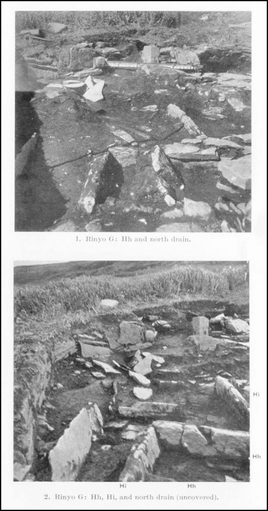
Less than 2 feet north of Hh and at almost the same level lay the other hearth, Hi. Its west kerb is 2 feet 6 inches long and 10 inches high. The south kerb, 6.5 inches high, has been broken off 2 feet from its junction with the western. The east kerb is missing altogether. The north kerb is represented by two fragments with a gap of 12 inches between them, but if completed would have been 2 feet 6 inches long. The gap in the north kerb and the truncation of the southern one are undoubtedly due to the north drain of G. Its channel cuts right through the red ash filling Hi, the last surviving slate of its south-west wall actually resting against the sloping face of the ash (P1. VII, 2). The top of the ash in Hi rises to 13.80 above our datum.
This hearth is embedded in a yellow clay floor, laid down before the present west kerb was put in position, which slopes up from 13.90 west of the hearth to 14.10 under the north wall of G. To the north the surface of the clay is stained green by the dung from the drain, and farther east it is cut through by that channel. In this floor, just north-west of Hi, there is a round bowl-shaped depression, 1 foot across and just 7 inches deep at its centre and lined with yellow clay. From its position and level the wall G’ might have framed a chamber in which Hi was the central hearth, but no further indications of the former existence of such a chamber, I, were detected within the area of G.
East of the area disturbed by the north drain we found, under the hearth and floor of G, slabs supporting an occupation deposit that might be associated with H or I or with any earlier deposit subsequent to 4. Right under Hg, but separated therefrom by a slab and clay layer, was a thin patch of red ash about 2 feet across. Near its northern margin was a shallow depression formed by slates tilted down so that their lower ends converged to form a sort of inverted pyramid. Farther east and north the floor of G rested on stumps of collapsed walls. The surviving slabs are in hopeless disorder, as if the later builders had torn out the better stones for use in their own work. So it is impossible to say whether these stumps once formed part of the walls encircling chambers H, I, or even E. In the north-east corner of G they rest on, or interlock with, the debris of a substantially earlier wall, T, on the stump of which the north wall of G and the east pier of its dresser rest almost directly. Farther west, the rest of the dresser, part of the limpet box and even the north half of Hi, rest on the debris of another early wall, J, the collapsed face of which mingles inconveniently with the ruins of T. In fact under the north end of G we found only wall debris and the unstratified packing that the walls had once sustained.
But south of the sloping edge of this tough packing the stumps of walls, trending east to west at an angle with the line of T, are embedded in and rest on a reddish ashy midden deposit nearly a foot deep below the floor of G’ from 14.24 to 13.30 under G’ at the south-west corner of the bed and under the banked clay inside the bed from 14.40 to 13.40. At its base three complete pot-bases were found. A similar midden deposit lay under the pavement at 15.40 immediately outside the door of G. Here the whole deposit was 18 inches deep, but the ash layers were interrupted by a band of paler ash mixed with more clay from 14.40 to 14.20, which corresponds roughly to the foundations of walls G and H. Below this band the ash went on down to a darker occupation deposit between 13.70 and 13.45, from which large fragments of several pots, two clay balls, and several fine flint implements were obtained. This deposit may be bracketed with that near the south end of the right-hand bed in G as 5a. It would seem to be older than H as well as G, since the base of the wall attributed to H lies upon it, but is later than 4, which is found below it and separated from it by another band of reddish ash 11½ inches thick.
Deposit 4. – The slabs first exposed at the base of Hh proved to belong to a crazy pavement that extended over the greater part of the area, later occupied by G, and beyond it to the south in the direction of D. This pavement consists of at least two layers of slabs, overlapping like drain lintels. The slabs of the upper layer do not rest tightly on those below them nor fit together very accurately, so that yawning gaps appear between them. The pavement was covered with an intensely black greasy deposit which fills up the gaps between the slabs and shows up as a black band in the walls of the excavation where the slabs have been pulled out. It constitutes Deposit 4. In the south-west corner lumps of peat were lying on the pavement included in the black layer. The overlying deposits of ash and wall stumps below the clay floors of G, H, and I had been fairly porous. The basal slabs of the pavement fit rather closely, and rest on a thin skin of clay that seals the red ash of Deposit 3 below. It looks as if the discharge of drains had been allowed to seep down to the pavement-level and flow away over it to the south.
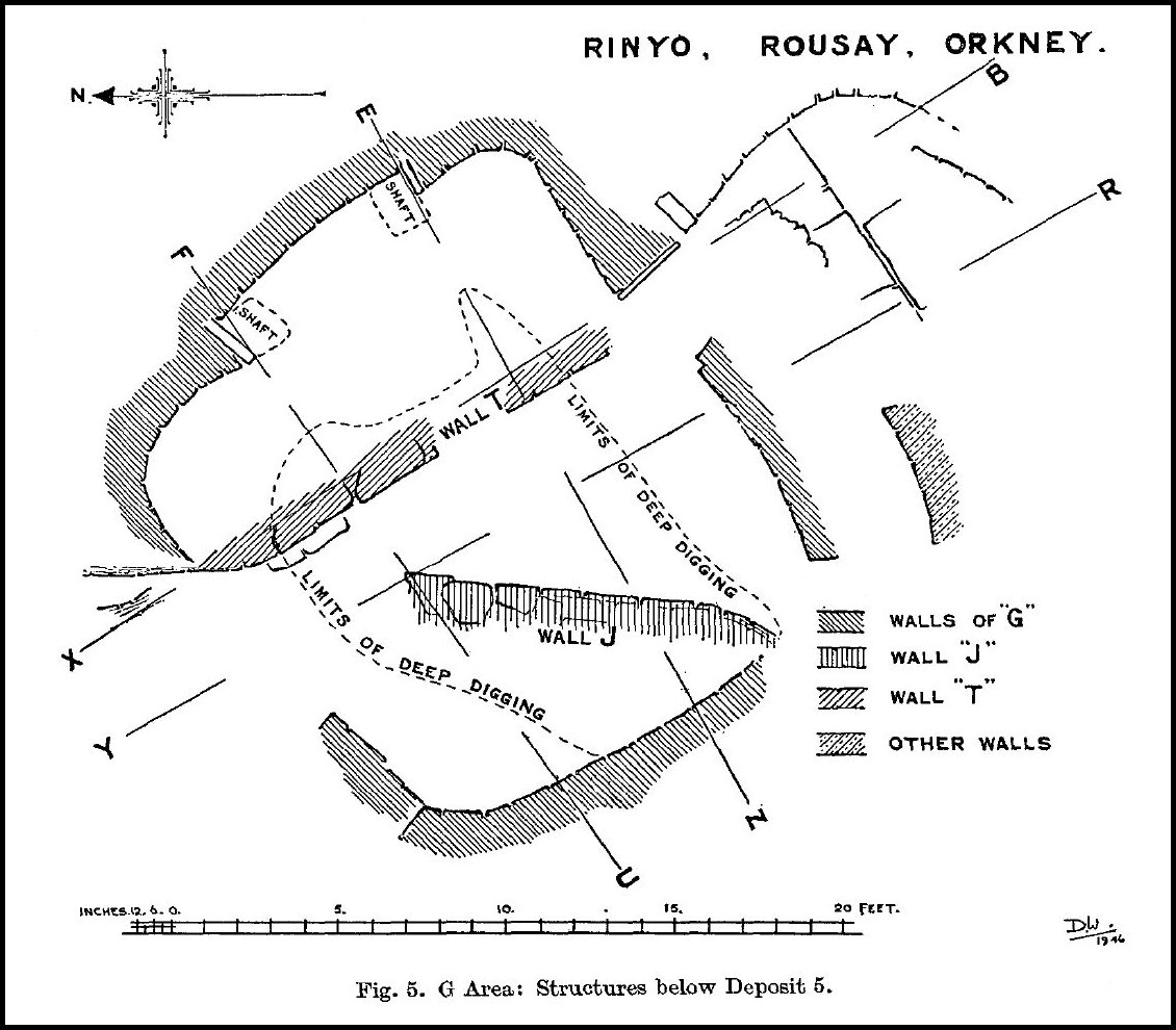
The pavement begins somewhere west of G, emerging from beneath its west wall about 13.00 above our datum between Hh and Hi (Pl. VIII, 1, below left). To the south we found it again with the appropriate black deposit outside the door of G at 12.85. Within the area of G, south of the middle of Hi, the pavement slopes up for 8 to 10 feet to a wall, T, running within the chamber north and south (fig. 5, above). This wall first appears, some 18 inches south of the east pier of the dresser, as a mere stump two or three courses high, with a level top at 13.60 which the black deposit and upper pavement slabs override. Six feet farther south it breaks off altogether. But after a gap of 3 feet, its line is resumed under G’ and could be traced under the entrance passage, but with its top here only 12.9 above datum. It was not picked up outside the door of G, probably because an eastward trend, already noticeable within the entrance, brought it outside the area accessible to excavation. Northward wall T continues but in much better preservation, so that, under the north wall of dwelling G, its top reaches 14.20 and actually supports the later wall. Here it is built with a heavy batter facing west-north-west and is beginning to curve away eastward (PI. IX, 1, below right).
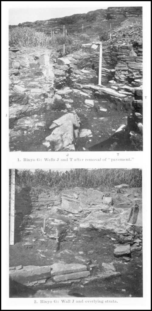
Wall T supports in the north a core of slabs and clay-and-rnidden packing on which the walls and floors in the north-east corner of G rests. Stones from its upper courses seem to have slipped forward over its stump to rest on the black layer at its base. They are perhaps hopelessly entangled with the similar debris from wall J that runs from the south-west corner of dwelling G obliquely towards wall T, so that it would have met it just where it begins to turn east. But, significantly enough, wall J breaks off before reaching wall T and, still more significantly, the pavement that generally overlies it itself fades out under the northern end of chamber G from about the centre of hearth Hi and so opposite the better preserved sections of wall T.
South of this sector the pavement of 4 ran up to the face of wall T, and its top layer actually continued over its stump for a couple of feet, up to the level of the front of the right-hand bed in G. But 2 feet 6 inches to 2 feet 9 inches before reaching T there is a partial interruption in its continuity (Pl. VIII, 2). The straight edges of three adjacent slabs at 13.25 to 13.45 all end along a line 5 feet long parallel to the “face” of T, that is resumed after a gap under the line of the south drain. This line looked like a wall edge, and for a foot or so actually did form a face two courses deep. But beneath it other slabs, overlapped by the three aligned ones, projected east of the line coming right up to the face of T at 13.05 – 13.40, and slabs from the higher pavement layer also projected beyond it. Though these looked like lintels they never actually reached, still less rested on, the stump of T. The black layer continued right up to the face of T, being 8 inches deep and rather looser in texture between it and the superficial break. Indeed this deposit continues across the line of T right up to the east wall of chamber G behind the bed, but it slopes up and grows thinner but rather tougher and more clay-like; in the north-east corner of the bed it is only 2 inches thick, lying between 13.65 and.13.85 above our datum. Probably it ran on under the wall to the foot of the steep rock-slope under the F area. For here we found a similar black band at about 14.90 to 15.00 above datum, on a level with the west drain under chamber E. But east of the line of T the black layer is tougher and poorer in sherds than under G among the paving-slabs.
Wall T looks like the casing wall of a chamber lying east of G. But there is clearly no room for a dwelling between it and the natural cliff behind E and F. Actually a wide trench dug to virgin soil outside G, but parallel to and only 8 to 10 feet east of T, disclosed no inner wall faces, articles of furniture, or deposit suggestive of such a dwelling, but only virgin soil at a higher level than the top of T. The packing T supported might then have constituted a platform, but it is uncertain what, if anything, stood thereon. The wall is presumably not only older than G but also than the midden deposits, termed 5a, that occur above its stumps. If chamber F were older than G and also than Deposit 5a, it could conveniently have been accommodated on a platform thus supported. No relics indicative of relative date were associated with the ruinous remains of F, but it would be surprising if so superficial a structure had been really very ancient. On the other hand it is possible that the pavement under G and to the south thereof is no older than wall T but actually composed of stones removed from its face. The basal paving-slabs, often over 3 inches thick, more than 2 feet 6 inches long and 2 feet wide, would make good building stones. The absence of the paving where wall T stands to a relatively high level, under the north end of G, would be explicable on this assumption. It is none the less certain, that the slabs had been deliberately laid out and that the pavement thus formed is substantially older than the overlying deposits and structures in the G area.
Deposit 3. – The basal slabs of the pavement just described in the south and west part of the G area rest tightly on a thin skin of pale clay that seals a deep layer of unusually bright red peat ash. This extends from the south-west corner to the line of the front of the right-hand bed eastward, and northward to the middle of hearth Hi. Farther north it seems to fade out in the midden packing under the north-west corner of G, but along line FU the red ash extends at least to the base of wall T and under slabs on which the foundation of this rests, at least up to the point where the north wall of G crosses it. Behind wall T only 4 inches of clay and ash, much less red than the typical ash of Deposit 3, intervene between the black layer (4) and the grey clay bed equivalent to (2). But farther south, where the line of wall T is broken away, a layer of red ash extends right up to the front of the bed between 12.95 and 12.30, though it is thinning out in this direction and is again more mixed with clay and small stones. At the base of the east wail of G, in the bed and outside the door, this red-ash layer is missing altogether, and the pavement of 4 rests directly on grey clay identical in texture with that underlying layer 3 elsewhere.
As found typically between the west wall of G and wall T, layer 3 seems to consist mainly of peat ash. It was very soft and wet, of the consistency of Orkney cheese. It was everywhere full of bones and bits of pottery, but these had been reduced to the same consistency. Under the west wall of G and Hh the deposit was about 8 inches deep, not counting 2 inches of more clayey material sealing it. In general, layer 3 contracts to the west; it is only 5 inches thick on the line of wall T at the point where this breaks off, and northward along the same line it has shrunk to barely 4 inches below the north wall of G at the base of the upstanding section of wall T. Here too it was tougher and mixed with more stones, partly perhaps because no longer separated from the overlying deposits by a continuous bed of slabs. But even here it retained its distinctive red colour and contained plenty of sherds and bones, as usual terribly disintegrated.
Deposits 2 and 1. – Under the south-west corner of dwelling G and under the top of a wall, J, emerges into the red layer. This wall curves in from the south-west as far as Hh and then, when only some 3 feet from the line of G’s west wall, begins to run fairly straight north-east till it is 7 feet 6 inches from that line and only 3 feet from the base of wall T. Here it breaks off (P1. IX, 2). Wall J is nowhere more than three courses high, but is certainly faced to the south-east and south with an already appreciable batter. Behind the line of face a tough packing of clay, stones, and midden looks like a wall-core. So J looks like the outer wall of a chamber assumed to lie to the west of G.
In front of the face there is a sort of paving of rather thin slaty slabs on which the foundation course rests. On this, against the face, there is a grey deposit of clay mixed with many fragments of rock and some ash, and all extremely tough. A similar deposit extends below the paving and underlies the red layer where wall J breaks off, and immediately underlies the black layer where the red is missing. It is generally almost sterile, but in front of wall J looks like a genuine occupation deposit containing plenty of sherds and bones and at least two Skaill knives – Deposit 2. Deeper down it passes almost insensibly into the yellow subsoil, but some-times, right on the latter’s surface, there is a thin band containing rather more but always minute fragments of bone and pottery. This rather questionable Deposit 1 may represent an old ground surface.
The subsoil slopes up steadily all over the area of G. Under the south-west corner living rock was exposed at 11.20 above our datum. Farther north along EZ the subsoil rises from the same level at the base of wall J to 11.80 in some 8 feet and then to 12.80 under the bed in the next 5 feet. There is presumably a ledge of rock under the front wall of the right-hand bed, and very likely another step under the east wall of G, since the next recorded reading; some 6 feet farther east under the E area, was 14.80. Similarly still farther north we reached subsoil at 11.25 on line FU between walls J and T, at 12.25 behind wall T in line with the bed’s front wall, and again at 12.80 in the north-east corner of the bed at the base of G’s east wall. Once more it has reached 14.00 just outside the G area only 4 feet farther east.
The K Area.
A test trench, 4 feet wide at base, was dug to virgin soil for a distance of 16 feet from the north-west corner of Hf, parallel to the wall of G. Traversing a comparatively level strip at the foot of the steep slope from the east, it revealed no regular occupation deposit nor any architectural remains save two adjacent slabs on edge standing quite isolated. The trench cut through a very poor midden deposit over 2 feet deep. This was interrupted by a distinct, but very narrow, black band at about 15.50, some 6 to 10 inches above virgin soil. It may be equated with layer 4 in the G area, but yielded no characteristic relics.
From the end of the south-north trench, which must have only just missed the back of wall T, a narrower oblique trench was driven uphill in a north-easterly direction towards some slabs on edge that had been noticed protruding through the turf. Along this line that is oblique to the contours, the turf surface rose from 17.50 to 20.50 in the first 15 feet and then levelled out for a space, while subsoil rose from 14.50 to 17.15 in about 8 feet. A bed of grey stony ash rose from 16 feet to 19.20 in the 15 feet. In this bed was intercalated the black band already noted for the first 6 feet only rising from 15.50 to 16.50, but it petered out at the latter level. Above the grey bed the humus covered a layer of reddish-brown ash midden, 8 to 12 inches thick.
At the top of the slope we encountered a bank of building slabs in great disorder, but probably the ruins of a wall. Beyond this the turf surface is more nearly level for a few yards up to the main line of cliffs, but has obviously been disturbed by quarrying in these cliffs. Actually at the top of the slope there is now an area at least 10 feet wide over which the subsoil is almost level at 18.90. It is on this shelf that the ruined wall and the slabs on edge actually stand.
On deturfing, the ruined wall proved to be hopelessly disturbed – posts have recently been driven in along its line – save for a slab on edge, D, near its northern end. But the slabs on edge proved to make a pattern reminiscent of a typical Skara Brae bed. A stout slab on end, A, 2 feet wide north-south, rises 2 feet above the soil, just like the headstone in a normal bed. Against its northern edge is leaning a thinner slab running east and west, 4 feet long and 1 foot 8 inches high, with two smaller slabs leaning against its end; would do well for a front kerb. But no east “headstone” survives, and there is no trace of a wall at the southern end of the extant “headstone” to mark the back of the hypothetical bed. A couple of feet north of the supposed kerb a stout slab, 18 inches long, leaning the opposite way might have been connected with a hearth, but no red peat ash appeared behind it. Three feet west of the bed a slab, D, 18 inches long and 22 inches high, is leaning against the bank of stones, assumed to represent the ruin of a wall; its base is nearly parallel to, but about 9 inches north of, the apparent line of the “bed’s” front “kerb.” It might once have formed the cheek to a doorway (fig. 1).
The kerb and headstone of the bed supported a small platform 2 feet wide, paved with small chips of stone set in a thin bed of clay, and this underlying clay extended for a further 3 feet south to the edge of our excavation at the same level. On it, just under the turf, was a thin layer of ash from which sherds of at least two thin-walled pots were recovered. Under the clay was another, greyer layer of ash that thinned out towards the east where the ground rises again. North of the bed kerb the clay bed of the platform and the superficial ash layer were both absent. The turf covered a tough but sterile bed of chips of rock and yellowish clay, apparently washed in, under which, however, there was a thin bed of greyish ashy material as under the platform to the south. It was from this that we recovered the half of a broken granite macehead, battered as if used secondarily as a hammer-stone. West of the headstone of the “bed,” the clay layer defining the platform was missing, but there was a single deposit of reddish-brown midden, 9 to 12 inches deep, right up to and beyond the ruined wall, and in fact continuous with that noticed on the slope in the connecting trench. This deposit contained many sherds, flints, and fragments of decayed bone.
Many sherds from the K area, especially those from the “platform,” belonged to relatively hard, thin-walled vessels. But coarse, thick fragments of standard Skara Brae ware occur here too, and include part of a vessel decorated with a single applied rib below the rim, but no more elaborately ornamented sherds. In addition to sherds several amorphous lumps of baked clay, reminiscent of fragments of moulds, were recovered, and a number of flint scrapers.
II Relics.
Pottery. – The stratified deposits in the G area yielded an instructive series of sherds, though all in very poor condition. The secondary layers, 7 and 8, contained remains of some fifty distinct vessels. Of these, eight or nine were made of relatively hard ware, 9 to 14 mm. thick, black externally and sometimes on the inside too, but still tempered with the coarse angular grits characteristic of Skara Brae fabrics. None of these is decorated, but some show a stepped bevel inside the rim (fig. 6, 1, 2). The remaining forty odd vessels are made of the familiar very coarse, soft fabric, tempered with large angular chunks of local rock; indeed a slice of a Skein knife, 21 inches long, was incorporated in one sherd (fig. 6, 4, and Pl. X, 5). The walls are generally over 15 mm. thick; the surface is fired brick-red. The roughness of the surface, due to the projection of the rock fragments, is only partially obscured by the application of a thick slip. All the vases are ring built. The bases are flat, most rims internally bevelled, usually with a step or ledge just under the rim inside. At least thirty were decorated with applied ribs, held in place by the slip (fig. 6, 7 below).
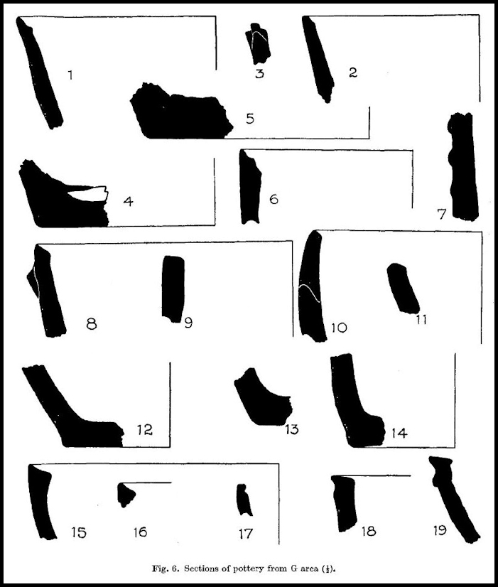
In addition to simple horizontal ribs, lozenges adorned four pots all from the latest level, 8 (Pl. X, 3, below); simple chevrons or wavy lines between the ribs, two, and combined with vertical lines, one; oblique ribs, joining two horizontal ones, distinguished four vessels, at least two from layer 8. Two pots from layer 7 were adorned with internal ribs on the base. One base of technically similar ware but undecorated, and found probably in layer 5 (fig. 6, 5), shows outside the impressions (Pl. X, 9) from the mat on which the vessel had stood while being built up; in some ten cases the rims were decoratively scalloped (Pl. X, 1).
Comparatively little pottery was actually lying on the original floor of G, though some sherds from the ploughed area in the west may really belong here. Most of the best attested vessels were plain. A double-bevelled rim (fig. 6, 6) found under the fallen kerb of the left-hand bed is noticeable. Scalloped rims are attested, but the peculiarly elaborate specimen, in which the scalloping looks like a twisted cable of clay attached to the rim, found at 14.25 among layers of burnt clay in the north-west sector, may really belong to 5 (Pl. X, 2); one of the twists of “cable” became detached in cleaning, and so shows how each twist was composed of a pellet separately stuck on to the rim.
Below the floor of G sherds were again embarrassingly plentiful, but few could certainly be connected with the occupations represented by Hh and Hi. These include part of the rim of a vase of hard ware, only 6 mm. thick, fired to a brownish hue and adorned externally with two flat horizontal ribs, obliquely slashed in a very successful imitation of cordons (Pl. X, 4). From the same context came a very thick sherd whose red exterior seemed to have been brushed over. We should have expected here true grooved ware, Skara Brae C ware, such as we found in 1938 in the deeper levels. No such typical specimens were recovered from the G area. The pattern on the sherd shown in Pl. X, 7, would be appropriate to grooved ware, but has been cut into the body clay. But the sherd, being much worn, may once have been covered with a slip that has peeled off. On the level of Hh we got one sherd with simple grooved lines in the slip (Pl. X, 6), a few others, equally simple, came from layers 5a and 4 outside the door, and from the red layer, 3, under G itself.
Quite a lot of pottery, including complete bases, was found near the bottom of the thick midden deposits, 5a, both in the eastern half of G proper and outside the door. Coarse, reddish, rock-tempered ware was still normal, but none of the sherds exhibited the rich decoration common above the floor of G, while the available rims were mostly simply rounded, none step-bevelled. But in these levels we began to encounter a different ware, grey to warm brown on both surfaces though blackish at the core. In this, large rock fragments are exceptional in the paste, the temper being composed rather of some material, presumably organic, that has disintegrated in firing, giving the ware what Callander happily describes as a “vesicular texture.” Though not heavily slipped, the surface is smooth, as the tempering grits no longer project from it; instead the surface is covered with little pits, giving it a “corky” look, to use Edwards’s descriptive expression. Technically this fabric is identical with that of many typical “Neolithic A” vessels from chambered cairns on Rousay (Craie, Kierfea Hill), Eday (Sandyhill Smithy, EO 741), and Calf of Eday (EO 622-3), and fairly close to that of one pot from Kenny’s Cairn, Caithness (EO 25), and to another from Unstan itself (EO 168). The available bases from layer 5a are indeed all flat, and the rims generally simply rounded (fig. 6, 9-11). But one vessel of grey ware (found among slabs at 14.05 above datum between the line of wall T and the front of the right-hand bed) has an internally bevelled rim and a low keel on the outside (fig. 6, 8). The keel is indeed formed by an applied strip, like the ribs of the typical Skara Brae vessels, but so, after all, are the carinations on Unstan bowls (at least from Midhowe, Rousay, EO 460, and Unstan, EO 167) and most Windmill Hill bowls from Man and Ulster!
Below layer 5 “corky ware” is still commoner, and some of the surviving rims can be matched among the vessels from chambered cairns. But, it must be repeated, rock-tempered soft sherds were still quite plentiful, though this soft fabric has suffered so badly from the damp that no estimate can be made of the relative proportions of Skara Brae and Unstan wares. The rare rims from the black layer, 4, include one simple rounded rim (152) of a Skara Brae pot with walls 17 mm. thick, and a squashed-down or bevelled rim (158) belonging to a deep bowl of corky ware (fig 6, 15), found on the pavement below Hi. In the corresponding deposit outside the door we got only one sherd of corky ware, several of rock-tempered, red-surfaced ware, one bearing lines grooved on the red surface (Pl. X, 8).
In the extremely wet red ash under the pavement that we term Deposit 3 this coarse, ill-baked fabric had been practically reduced to the consistency of butter mixed with stones. But it must have been fairly plentiful, and one of the sherds rescued showed a grooved line on the red surface. The better-preserved rims were in a different fabric. In No. 138 (fig. 6, 16) stone grits have been used as temper, but these are not the usual large angular fragments of local rock, but rather small water-worn fragments, really minute pebbles. Such pebble-tempered ware occurs together with the corky fabric in the chambered cairns of Rousay, Eday, and the Orkney Mainland (Unstan); indeed in describing the pottery from the stalled cairn on the Calf of Eday, Callander drew attention to “the occurrence of small pieces of stone, sometimes water-worn, in the paste.” The relevant sherds include plausibly “Windmill Hill” squashed-down rims that could be matched in the Neolithic A pottery from the chambered cairns of Unstan (EO 167), Taiverso Tuack (EO 371), and Craie (EO 765).
Finally, from the dark layer, 2, at the base of wall J came a typical club-rim, squashed down outwards (fig. 6, 18), and part of a vessel with a keel just below the fiat rim (fig. 6, 19). The latter can only be reconstructed as a shallow, round-bottomed bowl, and of the same general profile as classical bowls from Unstan; it is more exactly matched by a fragment (EO 625) from the chambered cairn on Calf of Eday.
It is therefore clear that the traditions inspiring the makers of the funerary pottery deposited in the classical chambered cairns of Orkney were alive in the Rinyo area when Deposits 2 to 4 and even 5a were laid down, although at the same time the curious and, as we think, inferior technique distinguishing the bulk of the pottery from Skara Brae was being used there too. Thus, in so far as chambered cairns and “Unstan” pottery define “Neolithic,” the primary occupation of Rinyo itself must be thus qualified.
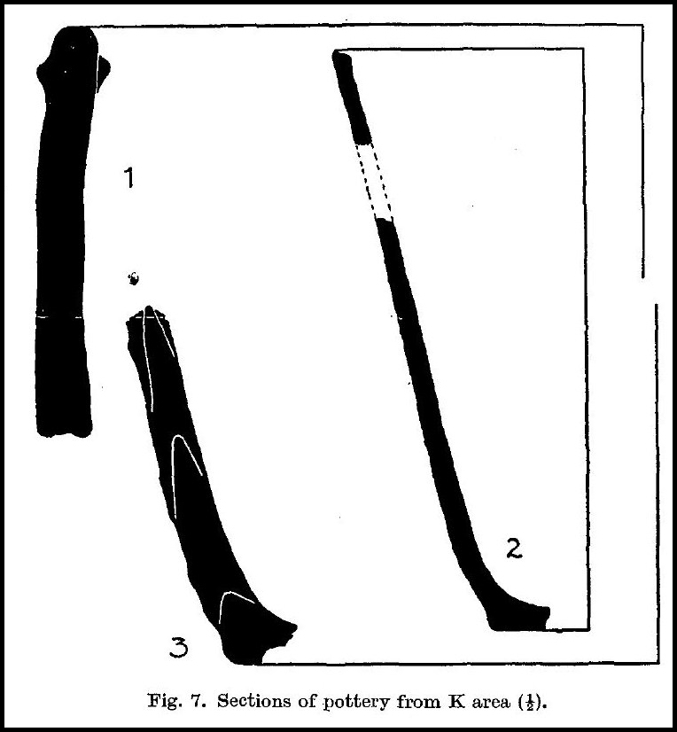
On the other hand, there is an Iron Age “feel” about the pottery from the very ruinous structure termed house K. Thin-walled, rather hard vessels, such as occurred above the floor of G, were prominent here. But again in the inclusion of grit as temper and in the internal bevel of some rims (fig. 7, 2), these carry on native traditions. At the same time a good deal of plain coarse ware of the usual soft kind was collected in the K area, and portions of one large pot decorated very simply with a single horizontal rib in the classical technique (fig. 7, 1, 3). It will be recalled that Stevenson in reporting on sherds from the “Potter’s Workshop” on the Calf of Eday detected there a survival of Skara Brae traditions into the Iron Age. So the finds from K make it likely, though they do not prove, that the occupation of the area continued into the Iron Age, and that ceramic and even architectural traditions were conserved to that phase.
Another feature of the K area was the discovery of several amorphous lumps of badly baked earthenware in which could be detected the casts of thin grass stems or rootlets that had been incorporated in the clay. These were at first taken for pin moulds, but may really be parts of very thick bases. At the base of the slope on top of which K stood in the exploratory trench driven north of F we found the base of a coarse pot, 7 to 9 inches in diameter, that was actually 1.7 to 1.8 inch thick!
Stone Implements.
No ground stone axe- nor adze-heads were found this year. A fragment from a polished stone celt was, however, recovered from the space between the inner face of G’s wall and the back of wall G’.
Skaill knives, not noted in 1938, were found in great numbers in the G area. No less than 160 were collected on and above the floor, and specimens occurred in all levels, one being found in the grey clay immediately overlying virgin soil (layer 3) and so undoubtedly in situ in the lowest archaeological horizon. Two smooth balls of camptonite were lying on the floor of G; one very symmetrical and smooth was found in the left-hand bed, but fell to pieces in transit.
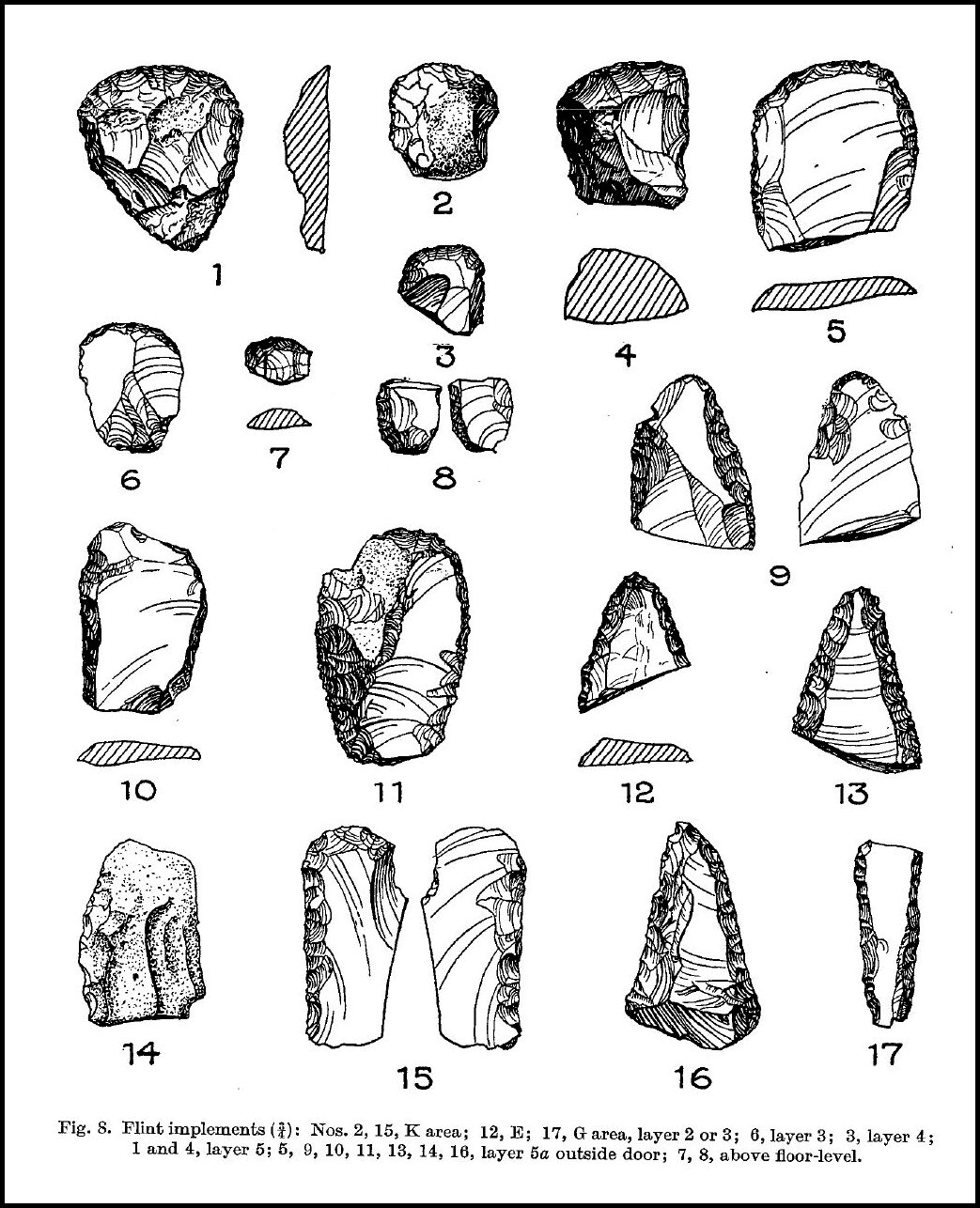
Flint implements too were fairly plentiful. The great majority were small scrapers; of these three came from the F area, ten from layers 6-8 in G, five from layer 5, one from 5a, and two from 4. But in the lower layers there was a sensible improvement in the quality and variety of the flint-work. Layer 5 yielded one large scraper, the 5a deposit outside the door four such, together with fragments of three knives neatly trimmed along the back. A knife-blade with steep trimming was the only flint from layer 3. Another knife-blade was found in dwelling E, only two small fragments on the floor of G. But a blade trimmed along one edge on both faces came from K (fig. 8, below).
A couple of small but typical anvil-stones from the floor of G must be considered in connection with the flint-knapping. Hammer-stones and rubbers were of course plentiful, but one rubber found in the north-west corner of G deserves special mention. It is a water-worn boulder measuring over all 9½ inches long x 6 inches wide x 5 inches thick. Its flattened oval upper surface, 8 x 5 inches, has been rubbed down, so that it is slightly concave longitudinally along one side, but the concavity extends over only 3 inches of its width; the rest of the surface is unground. Its shape is therefore unsuitable for grinding grain. In this context it may be remarked that no sickle gloss was observed on any of the flints any more than in 1938.
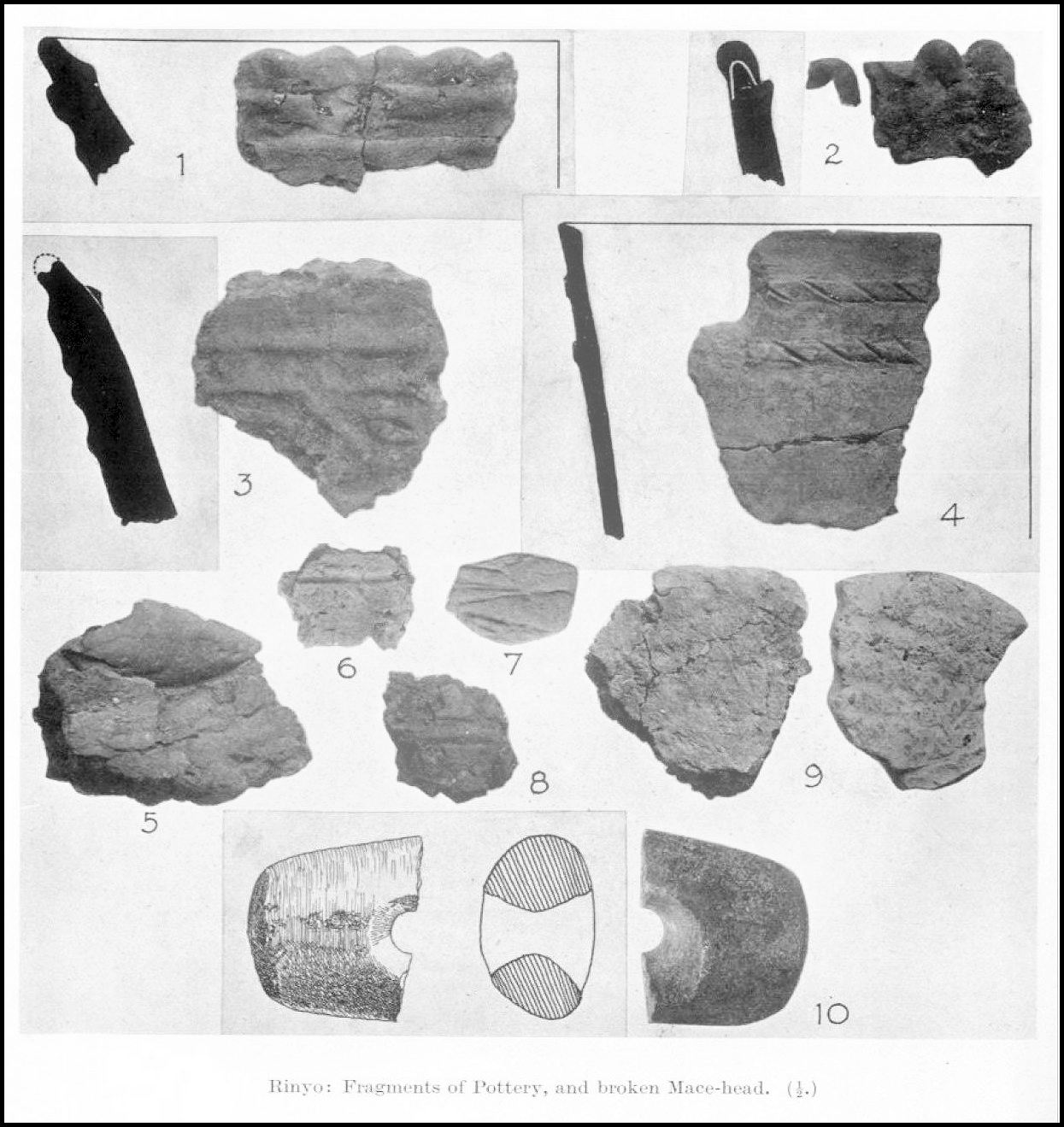
The broken mace-head from K is the twenty-sixth specimen to be recorded from Orkney (Pl. X, 10). It approximates to the pestle type and is made from a granitic stone. The perforation, however, is biconical, not cylindrical as in the best representatives of the type. The surviving end is abraded as if through use as a hammer-stone. The object would have had more dating value had it been complete and fresh. In view of its battered condition it may have reached the floor of K long after its manufacture and original use, whether warlike or ceremonial. Despite analogies in the chambered cairns of Arran, Caithness, and Rousay itself, the type is probably no earlier than the Middle Bronze Age of Southern England. It will be readily admitted that the relatively late phase of Skara Brae culture, exemplified by “house K,” was not earlier than that, and that is all we can infer from it.
Bone Tools. – Bone, unless burned, is consumed by the soil of Rinyo. But in deposits saturated with organic matter, and protected by slabs fallen against the wall of dwelling G, two implements were preserved. One was a pin or awl, made from an ovine metapodial, Skara Brae type A1, the other a fabricator, familiar at Skara Brae as type C. A section of a sheep’s metapodial, squared as if to make a cubical bead or a die, was found, burnt, near the hearth of E.
Miscellaneous.
Four little balls of clay, just like modern marbles, were found in early layers. Two came from 5a outside the door of G, one from between Hh and Hi, and the fourth from a deep layer under F. In view of the absence of flint arrow-heads, it would be tempting to regard these little balls as sling pellets. Such are regularly found in the numerous early sites in Iran, Hither Asia, the Balkan peninsula, and Southern Italy, from which arrow-heads are conspicuously missing. But these sling pellets are normally amygdaloid, not spherical.
A single lump of nodular haematite, such as is so common at Skara Brae, turned up this year well above the floor of G. Pieces of pumice, some grooved perhaps in sharpening bone awls, were relatively common and occurred as low as layer 5a. One appeared deliberately rounded. Several lumps of whalebone were observed, but all were too far decayed for any shape to be recognisable.
Part of a large stone basin or mortar lay high up in the midden over G. A large hole had been worn through the bottom by prolonged use. A small and rough stone “paint pot” or “lamp” was recovered from layer 3 under G. From the same level came a pebble that had been perforated as a pendant, but broken.
Charcoal.
As in 1938 quite a number of pieces of charcoal, all small, were discovered, and that at all levels. Mr M. Y. Orr, of the Royal Botanic Garden, has very kindly examined these for us, and recognised willow, birch, and alder, and perhaps poplar, but also pine and oak. The first named were presumably derived from local shrubs .or trees used as fuel. Pine, represented by at least two specimens, is less easily accounted for. In view of Erdtmann’s pollen-analyses, the growth of pines in Orkney during the last 5000 years seems unlikely. Mr Orr suggests it might have come in the form of driftwood. The single piece of oak (charcoal) was found under a secondary threshold slab just inside the door of G. Though we could not determine its shape, we thought it represented some artefact, perhaps a handle, even before we knew its material. A local growth of oaks is even less likely than pines. So it would represent an “import,” unless again it arrived as driftwood.

Part 2
Volume 81 (1946-47)
A Stone Age Settlement at the Braes of Rinyo, Rousay, Orkney.
(Second Report) (pp 16-42) Childe, V Gordon & Grant, Walter G.
Orkney Library & Archive ref: 941 – periodical section.